

17-Day Panama Canal Cruise
ITINERARY/JOURNAL
(Fred used a camcorder; Annette took photos for blog; used some pics from Google and cruise line site)
Wed Nov. 19
We checked into the Ramada Inn (Mall of America) for an overnight stay. The fall special price was $109 for lodging and 17 day parking. Accommodations were very nice. Complimentary USA Today
Thu Nov. 20
We took the 24-hour shuttle to the airport for American Airlines at 4 am. Flight # 770 to Miami.
In Miami we gave the waiting Holland America guide our voucher for the 25-mile transfer to the pier. Registration at the pier was very efficient and swift.

While we waited for the staff to deliver our luggage, we went up to the Lido deck at noon for a very adequate welcome lunch. The mandatory lifeboat drill was scheduled for 4:25 pm so we donned our orange life preservers. As we gathered at our assigned station on deck 3, we had a nice view of the Enchantment of the Seas (Royal Caribbean) docked at the neighboring berth. The crew over there was conducting a similar lifeboat drill.
Our ship left Fort Lauderdale, Florida around 5:00 PM as our fellow passengers congregated on deck to celebrate, led by the music of the HALcats. That evening we dined in the LaFontaine Dining Room at a table situated next to the large rear windows.

After dinner we walked to the opposite end of the ship to the Queen’s Theatre, where a great Showtime Welcome awaited us. I did not video the production because of an announced prohibition against videotaping these events.

Fri Nov. 21 At Sea
Following an ample breakfast we headed to a guest presentation on “Cartagena and the Spanish Main.” This interesting program was well attended and helped prepare us for our visit to our next destination.
The fame of this prosperous city turned it into the plunder site for pirates and thieves; hence the kings of Spain decided to approve the construction of castles, forts, and walls that surrounded the city. Despite the precautions, the city was attacked many times. In 1544 the French pirate Roberto Baal (aka Roberval) forced Governor Pedro de Heredia to flee and to give him gold to avoid being at the mercy of the invaders. In 1559, the Frenchman Martín Cote also dominated the city. He took huge plunder in spite of Cacique Maridalo's resistance.
Another pirate attack was that of Francis Drake, who disembarked at night and took the city at dawn; he forced the inhabitants to take refuge in the neighboring village of Turbaco, burned the houses and destroyed a nave of the Cathedral. Drake forced the authorities to pay him 107.000 ducats and confiscated some jewelry and 80 artillery pieces.


In 1568, the Englishman John Hawkins besieged the city for seven days, but Hawkins could not subjugate the city.
In order to resist these attacks, during the 17th century the Spanish Crown hired the services of prominent European military engineers to carry out the construction of fortresses, which are nowadays one of Cartagena's clearest symbols of identity. This construction took 208 years, and ended with: 1) some eleven kilometres of walls surrounding the city 2) the San Felipe de Barajas Castle, named in honor of Spain's King Philip IV, constructed to repel land attacks, equipped with sentry boxes 3) buildings for food and weapons storage 4) underground tunnels 5) the San Sebastián de Pastelillo Fort, in the neighborhood of Manga 6) the San Angel battery in Tierra Bomba 7) the San Fernando fort and 8) the San Jose battery in Bocachica, located strategically at the entrance of the bay to entrench the pirate vessels that attacked the city. In the 18th century, the Vaults were constructed by the Spanish engineer Antonio de Arévalo.
Entering the Harbor the Rotterdam will trace the path of the early galleons to the most important city on the main sea route, then known as: "The Spanish Main". The first indication that we are approaching Cartagena occurs miles from the city, as the ship glides right between two ancient Spanish Forts near Bocachica (Small Mouth), and then mid bay between the Forts of Castillo Grande and Manzanillo. As pirate ships appeared on the horizon, an under water chain was raised from the seabed between the forts, tightened and held fast, with a large capstan. With the ship held at bay, the ship was pummeled with cannon shot from the two opposing forts. As we continue our approach to the city we will see additional fortifications including the mighty Fort San Felipe de Barajas, which arguably is the largest and most impressive fortification in the New World.

The fortress is built of red brick and concrete, and designed so even if one part of the fortress fell to invaders (which never happened), the defenders could fire from another part. A complex system of tunnels connected strategic points of the fortress to distribute provisions and to facilitate evacuation. The tunnels were constructed in such a way that sounds reverberate all the way along them, making it possible to hear the slightest sound of the approaching enemy's feet, and also making it easy for internal communication.
Afterwards we filled in the free time relaxing. Fred brought along a book he recently checked out from the MLC library – The Age of Lincoln by Orville Vernon Burton. Usually the two of us filled up our extra time playing cribbage. There were always empty tables and chairs conveniently located with commanding views of the seascape. At 8:15 pm, following dinner, we were guests for the Captain’s Champagne Toast that was held in the Queen’s Lounge. Showtime immediately followed, featuring Broadway songs. Before retiring, the two of us put on our provided plush terrycloth bathrobes, and gave thanks for a wonderful time of recreation.
Sat Nov. 22 At Sea (caption)
Every morning we started the day out with a bowl of fresh fruit. Since we ate in the LaFontaine Room this morning with full table service, I ordered eggs benedict. The ship continued at sea all day so we put in a number of games of cribbage. Coffee (though quite strong) was always at hand. We did manage to take in an Art Lecture and look over the art collection (to be auctioned), which included works by Picasso, Rembrandt, Dali, Miro and other well-known artists. The evening’s Showtime entertainment in the Queen’s Lounge, as usual, could not be taped.
Sun Nov. 23 Cartagena, Colombia 07:00 AM 02:00 PM
We arrived early in Cartagena this morning. (Pronounced [kartaˈçena de ˈindias] in Spanish. Capital of the Bolívar Department, it has a population of 1,240,000 in its Metropolitan Area, and 1,090,000 in the city (2005 Census), being the fifth largest urban area in Colombia. Some passengers were understandably concerned about personal safety in the Port of Cartagena. The government seeks to put tourists at ease.
The Port cooperates fully with Interpol (of London, England) and the DEA (Drug Enforcement Agency) of the United States. There are video cameras everywhere, as well as a large contingent of well-armed and trained police, plus drug sniffing dogs. There is no need to be alarmed. The "troops" are friendly to tourists, and they can be helpful. A primary reason for this heavy security results from the insatiable demand for drugs consumed in the United States and other prosperous countries of the world. The U.S. State Department for years, has issued a Travel Warning to U.S. Citizens against visiting Colombia – that one should not take buses between cities, drive between cities or rent automobiles. Cartagena is a different situation.
According to Conde Nast Traveler (“Sleeping Beauty”
by David Ebershoff, March 2007): Even in the bloodiest times, the violence never reached Cartagena's walls. Why not? It's a question I ask nearly everyone I talk to about the city. There are a lot of theories. Some say it's because of the coral, brick, and quicklime walls that surround the historic center: Originally built by the Spanish, they've protected the city for hundreds of years. Former president Andreas Pastrana, who is the current Colombian ambassador to the United States, believes Colombians love the city too much to hurt it. "Cartagena is the symbol of Colombia," he says. "All Colombians take pride in it. During the years of violence, even the narco-traffickers respected it." A Wall Street analyst, who keeps a more jaundiced eye on Andean geopolitics for investors, jokes that even the terrorists needed a place to vacation. The difference between Bogotá and Cartagena is something like the difference between New York and Santa Barbara. In 2002, the Colombians elected Álvaro Uribe president on his platform of returning law and order to the country—a promise he has mostly made good on, thanks to billions of dollars in U.S. military support. (President Bush considers Uribe his strongest ally in left-leaning South America.) In four years, Uribe's right-wing government has managed to mostly contain the political violence to isolated inland regions; with a few exceptions, it is no longer a part of daily life in Bogotá, Medellín, Cali, and other major cities. Travelers still need to take precautions, but foreign tourists are beginning to return, and for many, the first stop is Cartagena. Cartagena is the most popular tourist city in Colombia. Foreigners stand out. When in a crowd, such as on a shore tour avoid all hustlers and beggars and try to ignore them.

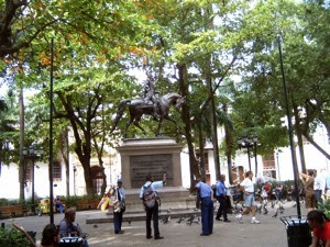
We decided that a self-guided walking tour would suit us best. Annette took photo above. This would allow us to proceed at our pace and spare us the overpriced Holland America excursion. First thing we did upon leaving the ship was to find a taxi and negotiate a price. They wanted $15 per head, but we offered $7 total for the two of us. We finally settled for $10 ($5 each) and were off to the Old Historic City. En route we passed a replica pirate ship with dancing girl pirates. Actually, more pirating was done on land as goods were plundered when it moved across land routes before reaching ports.
Our taxi dropped us off just outside the old walled city at the City Gate. The official entrance to downtown is through Puerta del Reloj (Clock Gate), which comes out onto Plaza de los Coches (see map) also known as the Square of the Carriages. The Clock Gate is the symbol of Cartagena, and often, Colombia, as well! The center gate originally was the only opening into the Walled City.

I took a video of a statue of the Spaniard Don Pedro de Heredia who founded the city in 1533. The Plaza de la Aduana (Customs Square) is the oldest and largest plaza in Cartagena and serves as the commercial heart of the city, and the parade grounds for festival days.


In front of the Plaza de la Aduana, it is one of the most representative houses of the colonial architecture (and well to do) in Cartagena. The low arches and elaborate wooden balconies are the product of the slave-trade fortune. The Spanish style buildings have been restored and are beautiful. Houses are painted in all shades of blue, burnt orange, salmon red and dull yellow.


Nearby was San Pedro Claver Square, and his namesake's church (below).The Spanish monk Claver ministered and gave medical care for slaves when no one else would. He also helped end the slave trade and was canonized for his life’s work in the1800s. Within the Church are remains of Saint Peter Claver, the first Saint canonized in the Western Hemisphere.

The first slaves arrived with Pedro de Heredia and they worked as cane cutters to open roads, in the desecration of tombs of the aboriginal population of Sinu, and in the construction of buildings and fortresses.
The city began to develop rapidly because of the slave trade. In fact, at the beginning of the 17th. century, the king of Spain granted the colony a monopoly on this "commerce." It is important to remember that at the time, the Spanish crown had forbidden the enslavement of Amerindians, but granted certain markets and key figures in its new colonies the right to deal in African slaves. Cartagena thus received the dreadful but highly coveted right to be an official slave-trading centre. Veracruz, Mexico was the only other centre of this kind. Cartagena was a major center of early Spanish settlement in the Americas as the Viceroyalty of New Granada.
We turned right from San Pedro’s Church (map) and walked over to Plaza Bolivar, The statue of Simon Bolivar is the centerpiece of the plaza.

Bolivar contributed immensely to the liberation of Columbia and other South America countries from Spain during the early 1800's. Cartagena was one of the first Colombian towns to proclaim independence from Spain, early in 1810. The declaration was signed on 11 November 1811, but the city paid dearly for it. In 1815, Spanish forces under Pablo Morillo were sent to re-conquer the town. It fell after a four-month siege but more than 6000 inhabitants died of starvation and disease.
In August 1819, Simón Bolívar's troops defeated the Spaniards at Boyacá, bringing freedom to Bogotá. Cartagena, however, had to wait until October 1821 for liberation, when patriot forces took the city by sea. Bolívar gave Cartagena its well-deserved name 'La Heroica', the Heroic City.
Large shade trees and palms making it a cool retreat for visitors surround the beautiful Bolivar Plaza. Venders ply their trades. Police seem to be everywhere, no doubt to insure safety for tourists.
Prominent on the plaza is the Palacio de la Inquisicíon (map), a fine example of colonial architecture. Behind the charming baroque facade, a museum displays instruments of torture (racks and thumbscrews included) from the Spanish Inquisition, pre-Columbian, colonial and independence-era art. On 5 February 1610, the Catholic Monarchs established from Spain the Inquisition Holy Office Court in Cartagena de Indias by a Royal Decree issued by King Philip II. The Inquisition Palace, finished in 1770, is still there with its original features of colonial times. When Cartagena declared its complete independence from Spain on November 11, 1811, the inquisitors were urged to leave the city. The Inquisition operated again after the Reconquest in 1815, but it disappeared definitely when Spain surrendered six years later before the patriotic troops led by Simón Bolívar.
Cartagena's Cathedral was directly across from the plaza. Cartagena's Cathedral, with its massive exterior, simple interior and fortress appearance begun in 1575, partially demolished by Sir Francis Drake's cannons, and completed in 1602. It has a colorful bell tower and 20th century dome.
From the Cathedral Fred walked back to Bolivar’s Square where Annette was in the process of purchasing a necklace from a street vendor. She wanted a matching bracelet so the gentleman sat down at the curb and custom made one for her. We walked back to the Clock Tower (City Gate) and took a taxi to the cruise terminal. As we returned to the Rotterdam, we encountered a Kodak moment, a view of the docked ship with beautiful flowers in the foreground.
I placed her photo above at the introduction of Cartagena.
Mon Nov. 24 Panama Canal, Panama Cruise Only: 05:00 AM 07:00 PM

The Panama Canal is a man-made canal in Central America that joins the Pacific and Atlantic oceans. See map. One of the largest and most difficult engineering projects ever undertaken, it had an enormous impact on shipping between the two oceans, replacing the long and treacherous route via the Drake Passage and Cape Horn at the southernmost tip of South America. A ship sailing from New York to San Francisco via the canal travels 9,500 km (6,000 miles), well under half the 22,500 km (14,000 mi) route around Cape Horn. Although the concept of a canal near Panama dates back to the early 16th century, the first attempt to construct a canal began in 1880 under French leadership.
After this attempt failed and saw 21,900 workers die, the project of building a canal was attempted and completed by the United States in the early 1900s, with the canal opening in 1914. The building of the 77 km (51 mi) canal was plagued by problems, including disease (particularly malaria and yellow fever) and landslides. By the time the canal was completed, a total of 27,500 workers are estimated to have died in the French and American efforts.
The canal can accommodate vessels from small private yachts up to large commercial vessels. The maximum size of vessel that can use the canal is known as Panamax; an increasing number of modern ships exceed this limit, and are known as post-Panamax vessels. A typical passage through the canal by a cargo ship takes around nine hours. 14,011 vessels passed through in 2005, with a total capacity of 278.8 million tons, making an average of almost 40 vessels per day.

The earliest mention of a canal across the Isthmus of Panama dates back to 1532, when Charles V, Holy Roman Emperor and King of Spain, suggested that a canal in Panama would ease the voyage for ships
traveling to and from Spain and Peru. During his exploring expedition of 1788-1793 Alessandro Malaspina demonstrated the feasibility of a canal and outlined plans for its construction.
An all-water route between the oceans was seen as the ideal solution, and the idea of a canal was enhanced by the success of the Suez Canal. The French, under Ferdinand de Lesseps, began construction on a sea-level canal (i.e., without locks) through what was then Colombia's province of Panama, on January 1, 1880. The French began work in a rush with insufficient prior study of the geology and hydrology of the region. Disease, particularly malaria and yellow fever, sickened and killed vast numbers of employees, ranging from laborers to top directors of the French company. Public health measures were ineffective because the role of the mosquito was then unknown. These conditions made it impossible to maintain an experienced work force as fearful technical employees quickly returned to France. Even the hospitals contributed to the problem, providing breeding places for mosquitoes inside the unscreened wards. Actual conditions were hushed-up in France to avoid recruitment problems. In 1893, after a great deal of work, the French scheme was abandoned due to disease and the sheer difficulty of building a sea-level canal, as well as lack of French field experience, such as downpours causing steel equipment to rust.[8] The high toll from disease was one of the major factors in the failure; as many as 22,000 workers are estimated to have died during the main period of French construction (1881–1889).
According to Stephen Kinzer's 2006 book Overthrow, in 1898 the chief of the French Canal Syndicate (a group that owned large swathes of land across Panama), Philippe Bunau Varilla, hired William Nelson Cromwell (of the US law firm Sullivan & Cromwell) to lobby the US Congress to build a canal across Panama, and not across Nicaragua.
In 1902, after having run into a 10-cent Nicaraguan postal stamp produced in the US by the American Bank Note Company erroneously depicting a fuming Momotombo volcano (which was nearly dormant and stands more than 160 km (100 miles) from the proposed Nicaraguan canal path) and taking advantage of a particularly volcanic year in the Caribbean, Cromwell planted a story in the New York Sun reporting that the Momotombo volcano had erupted and caused a series of seismic shocks. He thereafter sent leaflets with the above stamps pasted on them to all U.S. Senators as witness to the volcanic activity in Nicaragua.
On June 19, 1902, three days after senators received the stamps, they voted for the Panama route for the canal. For his lobbying efforts, Cromwell received the sum of $800,000.
The United States, under President Theodore Roosevelt (with John Frank Stevens as Chief Engineer from 1905-1907), bought out the French equipment and excavations, and began work on May 4, 1904, after helping Panama achieve independence from Colombia. In exchange for U.S. help in separating Panama from Colombia and setting it up as an independent nation, Panama would give the United States control of the Panama Canal Zone. The United States paid Colombia $25,000,000 in 1921, 7 years after completion of the canal, for redress of President Roosevelt's role in the creation of Panama, and Colombia recognized Panama under the terms of the Thomson-Urrutia Treaty. Chief Engineer (1905-1907), John Frank Stevens', primary achievement in Panama was in building the infrastructure necessary to complete the canal. He rebuilt the Panama Railway and devised a system for disposing of soil from the excavations by rail. He also built proper housing for canal workers and oversaw extensive sanitation and mosquito-control programs that eliminated yellow fever and other diseases from the Isthmus. Stevens argued the case against a sea level canal like the French had tried to build. He successfully convinced Theodore Roosevelt of the necessity of a canal built with dams and locks.
A significant investment was made in eliminating disease from the area, particularly yellow fever and malaria, the causes of which had recently been discovered by Dr. Walter Reed in Cuba with U.S. Army motivation during the Spanish-American War (see Health measures during the construction of the Panama Canal).
With the diseases under control, and after significant work on preparing the infrastructure, construction of an elevated canal with locks began in earnest. The Americans also gradually replaced the old French equipment with machinery designed for a larger scale of work (such as the giant hydraulic crushers supplied by the Joshua Hendy Iron Works), quickening the pace of construction, President Roosevelt had the former French machinery minted into pins for all workers who spent at least two years on the construction to commemorate their contribution to the building of the canal.

In 1907 US President Theodore Roosevelt appointed George Washington Goethals as Chief Engineer of the Panama Canal. The building of the canal was completed in 1914, two years ahead of the target date of June 1, 1916. The canal was formally opened on August 15, 1914 with the passage of the cargo ship Ancon. Coincidentally, this was also the same month that fighting in World War I (the Great War) began in Europe.
The advances in hygiene resulted in a relatively low death toll during the American construction; still, 5,609 workers died during this period (1904–1914). This brought the total death toll for the construction of the canal to around 27,500.
After WW II, United States' control of the canal and the Canal Zone surrounding it became contentious as relations between Panama and the U.S. became increasingly tense. Many Panamanians felt that the Canal Zone rightfully belonged to Panama; student protests were met by the fencing in of the zone and an increased military presence. Negotiations toward a new settlement began in 1974, and resulted in the Torrijos-Carter Treaties. Signed by President of the United States Jimmy Carter and Omar Torrijos of Panama on September 7, 1977, this set in motion the process of handing the canal over to Panamanian control for free as long as Panama signed a treaty guaranteeing the permanent neutrality of the canal (Neutrality Treaty) and allowed the U.S. to come back anytime. Though controversial within the U.S., the treaty led to full Panamanian control effective at noon on December 31, 1999, and control of the canal was handed over to the Panama Canal Authority (ACP).
Before this handover, the government of Panama held an international bid to negotiate a 25-year contract for operation of the canal's container shipping ports (chiefly two facilities at the Atlantic and Pacific outlets), which was won by the firm Hutchison Whampoa, a Hong Kong-based shipping concern whose owner, Li Ka Shing, is the wealthiest man in China.
Three pilots guided us through the canal starting at 5:30 am. We passed through the eastern locks, or Gatun Locks, around 9:30 as Annette finished her morning coffee. These three sets of locks had raised the Rotterdam 85 feet to Gatun Lake. “Mules” situated on rails along the shore pulled us through the locks. Annette took photos from the ship as we cruised the canal.
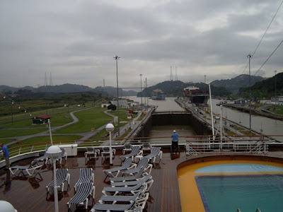


Further along we encountered the Gullard Cut, a channel that broaches the Continental Divide. Soon we passed under the Centennial Bridge. Panama's Centennial Bridge (Spanish: Puente Centenario) is a major bridge crossing the Panama Canal, and hence connecting North and South America. It was built to supplement the overcrowded Bridge of the Americas, and to replace it as the carrier of the Pan-American Highway; upon its opening in 2004, it became only the second permanent crossing of the canal.

The Centennial Bridge is located 9 miles north of the Bridge of the Americas, and crosses the Gaillard Cut close to the Pedro Miguel locks. Photo above is from Wikipedia.
Tue Nov. 25 Fuerte Amador, Panama City 5:00 PM
When we left the ship we were at Amador, a roadway/walkway built of rock excavated from building the canal. It extends outward from Panama' City and connects three separate small islands.

After the USA left, Panama' developed this area into a resort like area with expensive restaurants, shops, and the like. Details:
We chose to take the Holland America excursion “The Shaping of Panama” (prepaid on Discover) which departed at 8:10 am. Our white van was guided by a local Panamanian who started us off along the palm-lined Fuerte Amador. We headed first towards Casco Viejo, a dilapidated neighborhood of historic buildings and cobbled streets reminiscent of old Havana. Abandoned in favor of more stylish neighborhoods, Casco Viejo lay crumbling on the edge of the sea for decades. Our first site was the barrio where Roberto Duran grew up. He was raised in the corner building set off with a Pepsi sign. Roberto didn’t receive his education in a public school; he was kicked out in the third grade. Duran’s schooling came from the school of hard knocks. It was on the streets and in the gyms of Panama that Duran’s natural ability was honed into that of a consummate professional fighter

Roberto Durán (born June 16, 1951) is a retired boxer from Panama, widely regarded as one of the greatest boxers of all-time. During his career he would be called in admiration "Manos de Piedra," which translates to "Hands of Stone". He held world titles at four different weights - lightweight (1972-79), welter- weight (1980), junior middleweight 1983-84) and middleweight (1989). The one aberration on Duran’s record is the infamous “No Mas” fight in his rematch against Ray Leonard.
A short stretch down the street we found an ambitious reclamation of this colonial district that had taken place in recent years. We drove through the streets of the old French Quarter founded in 1763 by French colonists. The city’s architectural diversity is rivaled only by its cultural diversity. Next we were in store for a real treat, the city square.
The Metropolitan Cathedral (Catedral Metropolitan) is without a doubt the most meaningful structure, and best reflects the Spanish presence due to the buildings dimensions and age; the construction of this building lasted more than 108 years.
In front of the cathedral is a large park (plaza), in which the community reunited on November 3, 1903 in order to declare its separation from Columbia. It was at that moment that the Republic of Panama was born, with much euphoria. Surrounding the plaza is the Municipal Palace (Palacio Municipal) with its neoclassical characteristics, which was occupied by the
French when they began construction of the Panama Canal; the canal was later completed by the United States. The building is being completely remodeled to house a museum that will more adequately depict the construction, function, importance, and future of the canal.
Next on the agenda was an elaborate vaulted promenade along the oceanfront. Under the Republican Era, this French Park (Plaza de Francia) was constructed, dedicated to those who explored the route and began construction of the canal. Flowers set off the entrance area where the ubiquitous vendors displayed their wares. From the walkway we had a commanding view of the ocean. The tide was out, revealing large areas that had been previously covered with water. To the left we could see the skyline of the modern buildings of Panama City. Straight ahead was our ship Rotterdam anchored in the harbor. Then off to the right in the distance was the Bridge of the Americas. The Puente de la Américas arches gracefully over the canal.

The French flag hangs to the side of the park, in one of the balconies of the French Embassy. The "Plaza Herrera", with the statute of French heroes, was another site worth visiting.

It is located very close to the "Iglesia de San Jose", with it's famous alter of gold, which helps demonstrate Panama's links with Spanish artists. "El Paseo de las Bovedas", which is the old Spanish military fort, allowed the city's most select families to view the afternoon sunsets and meet government officials.
Our tour guide gave us some free time so I ventured (solo) over to the Church and Convent of Santo Domingo. We had passed this site earlier, but the van did not stop.
The Dominican friars began to build their church and convent in new Panama immediately after the founding of the city. In Old Panama they had a substantial building of stone, and some of this entered into the edifice in the new city. In the fire of 1756 all the woodwork was burned and the church was not rebuilt. Near the main entrance, forming on of the supports for the choir is a brink arch, spanning a space of 50 feet, 35 feet high at the crown and 25 feet at the spring. So flat an arch is said to be an engineering “sport,” and is pointed out as one of the sights of the city. It was declared that no arch so flat could remain in place without mechanical aid of some sort, and it was alleged that there was a concealed beam or plank running though it. When the ruins of the church began to be removed in 1913 and the arch was examined, it was found to be a genuine construction of masonry, and not a fake.
Back at our meeting spot, I taped some attractive flowers that had caught my attention. We loaded into our white van and proceeded through the modern city of Panama via Av Central España, the section that traverses the ElCangrejo business and financial district. Today, Panama City is by far the wealthiest city in Central America, and residents are wholly optimistic about the future – and with good reason. Following the handover of the Canal in 1999, and the subsequent closure of American military bases in the country, Panama City is finally in charge of its own destiny. Furthermore, a spate of foreign investment and the recent referendum to expand the Panama Canal means that the capital is likely to continue its remarkable boom.
After leaving the business district we took a short detour into upscale neighborhoods of Pujnta Paitilla and Golf Heights, including a drive past the former residence of the infamous General Manuel Noriega.

In the late 1970s through the 1980s Panama became an international banking center, bringing a lot of undesirable attention as an international money-laundering center. By the late 1980s, relations had turned extremely tense between Noriega and the United States government, due to allegations that he was spying for Cuba under Fidel Castro. In 1989 the general was overthrown and captured during Operation
Nifty Package, as part of the United States invasion of Panama.
He was detained as a prisoner of war, and later taken to the United States. In 1992 he was convicted under federal charges of cocaine trafficking, racketeering, and money laundering in Miami, Florida. Sentenced to 40 years in prison (later reduced to 30 years), Noriega is held at the Federal Correctional Institution, Miami.
The best part of our tour was visiting the ruins in the closing portion of our tour – Panama la Vieja. Old Panama was founded on August 15, 1519, by Pedro Arias de Ávila. Within years of its founding, the city became a launching point for the exploration and conquest of Peru and a transit point for gold and silver headed towards Spain. We began our tour at a museum with exhibits of the early history here. Drawings depicting the confrontation of Spanish and natives were on display. Outside the Museo was a statue of Pedro Arias de Ávila who founded the city. From here we drove past countless remains of structures testifying to the expanse of the early settlement.
These extensive ruins are all that’s left of the original Panama City. Two of the best-preserved structures are near the main entrance. The first is the tower of the cathedral, which is largely intact.

It’s one of Panama’s national symbols and was built between 1619 and 1626. The other, a bit farther in, is the Casa Alarcón, also known as the Casa del Obispo (bishop’s house). Built in the 1640s, it was a three-story building with a wooden top floor. It’s the largest and most intact house on the site, but still just fragments of walls. A restoration project is buttressing the crumbling, rough-hewn stonewalls with red bricks completely out of keeping with the original architecture. There were convenient signs in both English and Spanish that explained the history of the ruins.
In 1671, the Welsh pirate Henry Morgan, with the help of a band of 1400 men, attacked and looted the city, which was subsequently destroyed by fire. The city was rebuilt in 1673 in a new location approximately 5 miles (8.0 km) southwest of the original city. We had visited this location, Casco Viejo (Old Quarter), earlier on our tour.
Our tour van brought us back to Amador causeway where we boarded a waiting tender for our return to the Rotterdam. Great daily excursion! Our evening entertainment aboard ship was “Showgirl” featuring the cast of the Rotterdam. No video, of course.
Wed Nov. 26 At Sea
Breakfast, as usual, was bountiful. At 10 am we made ourselves comfortable in the Queen’s Lounge for the Speakers Series. Today’s feature was “The Maya Then and Now” presented by Dario Bollacasa. The illustrations brought back memories of my earlier encounters with Maya civilization near Cancun– unbelievable sophisticated works of art and architecture!

The Classic period (c. 250 CE–900 CE) witnessed the peak of large-scale construction and urbanism, the
recording of monumental inscriptions, and a period of significant intellectual and artistic development,
particularly in the southern lowland regions. They developed an agriculturally intensive, city-centered
empire consisting of numerous independent city-states. This includes the well-known cities of Tikal, Palenque, Copán and Calakmul.
The most notable monuments are the stepped pyramids they built in their religious centers and the
accompanying palaces of their rulers. The palace at Cancuen is the largest in the Maya area, though the site, interestingly, lacks pyramids. Other important archaeological remains include the carved stone slabs usually called stelae (the Maya called them tetun, or "tree-stones"), which depict rulers along with hieroglyphic texts describing their genealogy, military victories, and other accomplishments.
For reasons that are still debated, the Maya centers of the southern lowlands went into decline during the 8th and 9th centuries and were abandoned shortly thereafter. This decline was coupled with a cessation of monumental inscriptions and large-scale architectural construction. Although there is no universally accepted theory to explain this “collapse,” current theories fall into two categories: non-ecological and ecological.
Non-ecological theories of Maya decline are divided into several subcategories, such as overpopulation, foreign invasion, peasant revolt, and the collapse of key trade routes. Ecological hypotheses include environmental disaster, epidemic disease, and climate change. There is evidence that the Maya population exceeded carrying capacity of the environment including exhaustion of agricultural potential and overhunting of megafauna. Some scholars have recently theorized that an intense 200-year drought led to the collapse of Maya civilization. The drought theory originated from research performed by physical scientists studying lakebeds, ancient pollen, and other data, not from the archaeological community.
Today, the Maya and their descendants form sizable populations throughout the Maya area and maintain a distinctive set of traditions and beliefs that are the result of the merger of pre-Columbian and post-Conquest ideologies (and structured by the almost total adoption of Roman Catholicism). Many different Mayan languages continue to be spoken as primary languages today/
At 11 am we followed up with an art seminar entitled “30,000 years of Art History in 30 minutes. I sure wouldn’t want to try to cover all that territory in 30 minutes. I was curious just how that would be accomplished and promised myself not to be too critical. I liked some of the choices, all well known, that she used for examples of period art.
We cruised the scenic Golfo Dulce. Dinner tonight was great -- topped off with blueberry pie and ice cream.

Thu Nov. 27 Puerto Caldera, Costa Rica 07:00 AM 06:00 PM
An important port in the Pacific, Puerto Caldera sits near the mouth of the Golfo de Nicoya. Located in the northern region of Puntarenas province on the Central Pacific Coast, this tiny town is a key port for ships from all across the globe. With an industrial port complex built here to accommodate both cruise liners as well as cargo vessels; Puerto Caldera plays a vital role in Costa Rica’s trade with the world. We had decided to sign up for (prepaid on Discover) Holland America tour “Tropical Train Ride & Exotic Mangrove Glide” which departed at 8:30 am. The excursion was to last approximately 51⁄4 hours.
First of all we boarded a large bus at the pier to take us to the mangrove portion of the package. To our delight, Rose and Blanche (and their husbands) boarded the same coach. We met these delightful “New Yorkers” earlier on the ship as we were playing cribbage. We headed to the Tarcoles River.
Music greeted us at the visitors’ center. Flat bottom swamp boats with open viewing awaited us at the dock.


Here, we enjoyed the tropical mangrove adventure. Pure, untouched nature surrounded us as we saw different species of mangroves, Definition: Mangroves (generally) are trees and shrubs that grow in saline coastal habitats in the tropics and subtropics. The word is used in at least three senses: (1) most broadly to refer to the habitat and entire plant assemblage or mangal, for which the terms mangrove swamp and mangrove forest are also used, (2) to refer to all trees and large shrubs in the mangal, and (3) narrowly to refer to the mangrove family of plants, the Rhizophoraceae, or even more specifically just to mangrove trees of the genus Rhizophora.
The Tarcoles River forms the northern border of the Carara Biological Reserve, and is well known for its American Crocodiles, while at its mouth the marshes are have many waterfowl and wading birds. The many herons and egrets include the Boatbill and Bare-throated Tiger Heron, and other birds found here include Double-striped Thick-knee, Mangrove Warbler and American Pygmy Kingfisher. Reptiles like the American Crocodile, Cayman, Common Basilisk and large iguanas are readily seen. To our surprise we saw a family of raccoons scampering about the boarding area. At the end of boating excursion we relaxed at the visitors’ center for drinks, including a tasty local beer and tropical fruit.
After another bus trip we were ready for phase two of our excursion. We boarded the historic Pacific Railroad that was used to transport the country’s valuable coffee harvests from the highlands to the coastal ports. I taped both theexterior and interior of our railroad car. Apparently the interior was recently refinished with varnished wood. This guided train ride took us through small towns and past incredibly rural and tropical scenery. Throughout the journey, large picture windows allow us to experience all the beauty of Costa Rica’s countryside.

Bottled water was offered during the train ride. At one train stop I videotaped a young girl who was watching us tourists watch her. Back on the ship we celebrated Thanksgiving with an elaborate dinner in the LaFontaine Dinning Room. Annette had a huge shrimp cocktail for starters. This was followed with the traditional turkey plate -- and pecan pie for dessert. Comfortably stuffed, we waddled to the other end of the ship for the Filipino Crew Show held in the Queen’s Lounge.


This cultural production we were not only permitted to tape, but were encouraged to do so. Following the Philippine National Anthem the entertainment began with a graceful Castanet Dance performed by traditionally dressed dancers. Humor was provided by a singer half dressed as a man and half dressed as a woman. When his man side faced the audience he used his normal male voice, but when he switched side he revealed his female half and impersonated a woman’s voice. I personally do not care for sex impersonator acts, but this person had a good voice(s) and was really hilarious. This was followed with a song number from one of the crew’s bartenders who was quite dynamic. We talked to him the next day and he said he was really scared on stage, but we told him it didn’t show. The best part of the show was the Tinikling Bamboo Dance. The bamboo clappers smacked bamboo poles together as dancers performed their routine by delicately (and quickly) stepping between the moving bamboo poles.
Fri Nov. 28 At Sea
Today was spent at sea. Annette allotted considerable time for doing the laundry at the ship’s self-serve laundromat. The captain announced the sightings of sharks and sea turtles over the PA. Annette had crab legs for dinner. Our nighttime entertainment presented the great pianist Elliot Finkel, but I did not record him. He may be viewed on www.youtube.com/watch?v=2fhPVmC6WzE - 67k Mr. Finkel is a large man, and when he set his mind to playing loudly, which he did at the slightest opportunity, it was a fearsome display.
Elliot has appeared on the great stages of the world including Carnegie Hall, Hollywood Bowl, London Palladium and three appearances at the White House. Some of the symphony orchestras he has performed with include Los Angeles, Washington, D.C. (National), Baltimore, Dallas and the Queens Pop Orchestra, which he served as music director for two seasons. He has played hundreds of recitals across the globe, both as a soloist, and together with his brother, Ian Finkel, xylophone virtuoso. Three times he has costarred on Broadway with Michael Feinstein, with Sid Caesar, and with Ian Finkel and their father, Fyvush Finkel. Mr. Finkel’s concerts have become a favorite on cruise ships of the world, such as the QE2 and the Rotterdam. He has played and conducted for such diverse artists as Ginger Rogers, Milton Berle, Danny Thomas, Regis Philbin, and Theodore Bikel. He is proud of his eight-year association with the legendary tenor, Jan Peerce.
Sat Nov. 29 Puerto Quetzal, Guatemala 06:00 AM 05:00 PM
This is the first time we have been in Guatemala and we looked forward to it. Guatemala is a land of tropical jungles, active volcanoes, mountain lakes, mountain cloud forests, volcanic beaches and coral reefs.
Puerto Quetzal where we landed is a cruise-port, which serves as a gateway to the Guatemala's inland attractions.
Holland America’s land excursions were overpriced so we decided to join with others at the pier to negotiate a price with the locals to travel inland to Antigua. We (10 people) arranged a guided tour in a van for the reduced price of $35 per person. Holland charged $39 for On Your Own travel only.
It was a 90-minute drive through the scenic countryside to colonial Antigua. Our lovely guide traced our route on a map. The first stop was to be a coffee plantation where a local woman made tortilla, a type of thin, unleavened flat bread, over an oven and served them with avocadoes. They tasted good.


Young ladies were weaving cloth with a rainbow of colored threads.
I took a picture of some poinsettias before going with the group to the coffee plantation. After we returned to the center, Annette purchased a pound of Guatemala coffee.
We drove down from the mountain and entered the city of Antigua; we passed the main square, the Plaza de Armas, but did not stop. Our guide promised we would visit here later on. Our major objective was Iglesia y Convento de Santo Domingo, the biggest and richest monastery in Antigua. It had been founded in 1542. Its large church was completed in 1666. Damaged by three 18th-century earthquakes, the buildings were further depleted when pillaged for construction material in the 20th century. The site is currently occupied by the Hotel Casa Santo Domingo.
At the receptionist desk were flags denoting the origin of the complex. The grounds were well kept with open plazas everywhere. Flowers and birds (macaws) dotted the landscape.
The archaeological areas (áreas arqueológicas) form part of the paseo de museos (museum walk). It includes the very picturesque ruined monastery church now used for mass and weddings. As we walked around we encountered caters preparing for an impending wedding. The adjacent cloister with its large fountain created in 1618, and two crypts discovered in the 1990s - one, the Cripta del Calvario, boasts a pristine mural of the Crucifixion; the other holds two graves with human bones. The paseo also includes museums dedicated to colonial and contemporary art, archaeology, handicrafts and even a pharmacological museum.

We finished our Santo Domingo tour around lunchtime and our tour guide had us then taken to a picturesque part of town (see map) for lunch. Down the street from our restaurant was the Santa Catalina Arch, which had become a symbol of the city.

The only remnant of the once-enormous Convent of St. Catherine is this beautiful yellow arch that spans 5 Avenida Norte, a street locals call Calle de Santa Catalina. The convent was founded in 1613 with only four nuns, but by 1693 its growing numbers forced it to expand across the street. The arch was built to allow the sisters to pass from one side to the other unseen. It was rebuilt with its clock tower in the 19th century.
La Merced Church and Convent may be seen in the background beyond the arch. The church is one of the most beautiful in Antigua, featuring intricate and ornate patterns in white stucco on a yellow background. The church is also a good example of the "earthquake baroque" architectural style popular by necessity in Central America: short squatty bell towers, in contrast to the soaring towers of the churches built in seismically less active Mexico during the same epoch. The Iglesia y Convento de Nuestra Señora de La Merced is Antigua’s most striking colonial church. La Merced’s construction began in 1548. Improvements continued until 1717, when earthquakes ruined the church. Reconstruction was completed in 1767, but in 1773 earthquake struck again and the convent was destroyed. Repairs to the church were made from 1850 to 1855; its baroque façade dates from this period.
The restaurant our guide selected on this street was as elaborate inside as it was expensive. It featured an open court with beautiful flowers and a fountain. Annette ordered a local beer and shrimp salad while Fred settled on a vegetable salad with coffee.


After lunch we walked a considerable distance to a Jade outlet store (note Maya jade masks on video). Every tour includes these time consuming things that end up in a showroom.

Guides rely heavily on kickbacks from the proprietors. This would not have been so bad if it did not mean missing the historic square of the city. I reminded our guide that time was running out, but we had to wait until every possible purchase could be made.
When I saw the Cathedral ahead on our return trip, I asked the guide if the bus could not at least stop at the Plaza de Armas. She so instructed the driver. From my seat I videoed the Cathedral located on the east side of the plaza.
The great Cathedral was inaugurated on Nov. 5, 1680, after eleven years of construction. This huge building replaced an earlier cathedral begun in 1542 and worked on intermittently for many decades. Various notables from the Conquest were buried here: Bernal Diaz del Castillo, conquistador and author of The Discovery and Conquest of Mexico, lived out his latter days in Antigua and was buried in the original cathedral; the remains of the Don Pedro de Alvarado, the conqueror of Guatemala, were brought here in 1568 for re-interment.
The present day church is a reconstruction of a small portion - only as far back as the first two bays- of the front of the cathedral. This reconstruction was completed in the 1820s, when the cathedral was converted into a parish church. The present church differs only in minor ways from that shown in a 1784 sketch of the cathedral, and the lower story is very likely much as it was when first completed in 1680.
To the right was the Palace of the Captains-General, which for more than two centuries was the seat of Spanish colonial government.

Construction was begun on the original building in 1549 and completed in 1558, but the building has been repeatedly reconstructed and altered following damaging earthquakes. In 1735 the Casa de la Moneda (mint) was inaugurated in this large complex. But most of the structure was destroyed in the 1773 quakes that brought the city to its knees. Today the beautiful two-tiered arched structure has been restored, and the building houses government, city police, and INGUAT (Guatemala Tourist Institute) offices, but the present palace is but a small remnant of the former complex. The palacio was yet again heavily damaged in the Feb. 4, 1976 earthquake. Earthquakes destroyed almost everything but the façade (with insignia of the Bourbons).
We returned to the Rotterdam only fifteen minutes before sailing. We spruced up for a special Master Chef’s Dinner, which featured dinning room stewards dancing, and swinging towels tableside. Following the festive ceremony we were treated to a special dinner and special desert.

Sun Nov. 30 Huatulco, Mexico 11:00 AM 06:00 PM
Quetzalcoatl, the feathered serpent god of Mesoamerica, the Traveler and Bringer of Civilization, is said to have appeared on the Pacific coast of southern Mexico around 2,000 years ago.

He came in the form of an old, bearded white man and planted a piece of wood in the shape of a cross on the beach. The visit gave the spot a name: Huatulco, the Place Where the Wood Is Adored, as well as its first taste of foreign tourism.
We booked (prepaid) the Holland America tour “La Crucecita and Scenic Drive” which departed at 1 pm. and took about 3½ hours. The tour guide met us at the ship and instructed us to follow him down the long, long pier to the bus. A shuttle was available for $2 but we chose to walk with the guide.
Our bus took us past the Tangolunda Bay district—home to deluxe hotels and fashionable housing estates. We saw many roadways and improvements that had been constructed well in advance of actual occupation. In 1984, FONATUR (Fondo Nacional de Turismo), a government agency dedicated to the development of tourism in Mexico, acquired 21,000 hectares of land to develop a tourism center, similar to that in Cancun. The existing population was relocated to Santa María Huatulco along the beach (which we saw from the bus). The plan resulted in the improvement of roadways and other infrastructure. It also had populated areas interspersed with "green zones" to make the area more ecologically-minded. In fact, this is one of the cleanest developments in Mexico.
We continued to Conejos Bay and the Copalita River estuary for breathtaking scenery.


Our last stop was to La Crucecita, a quaint town and emerging resort, and spent one hour independently browsing around of the central plaza. The first site was the Cathedral, which boasts the largest ceiling mural of the Madonna in Mexico. I personally think the claim was invented to create a source of tourist revenue. Two collectors stood at the door collecting the required $2 entrance fee. We did not bite.
The square was like a well-kept park and the benches in the shade provided us a welcomed rest stop.


The last agenda for this tour was at La Entrega Viewpoint for a chance to take photos of our ship, the beach and the coral reef. We wrapped up out tour with a trip back to the pier. When we returned it was very hot so Ann then opted for the $2 shuttle bus back to the Rotterdam.
That evening, after dinner, as we were walking to the front of the ship for Showtime, we passed the Sportsmen Bar where the Viking game was on television. The competition was with the Chicago Bears and had just started. We immediately changed our plans and watched the game. The Vikings won!
Mon Dec.1 Acapulco, Mexico 08:00 AM 11:00 PM
The Rotterdam pulled into the Bay of Acapulco at 8 am. After breakfast in the Lido Restaurant, I taped the imposing Fort of San Diego and the bay over which it presided. Photo from TourByMexico.com

The Fort of San Diego is the most relevant historic monument in Acapulco and was the most important Spanish fortress along the pacific cost. Located on a hill in the heart of downtown Acapulco, the fort is an integral part of the landscape that stands out because of its singular geometric design in the shape of a five-point star.
A lot of history had taken place here.The first reference to Acapulco in the history of the Viceroyalty of New Spain was made as early as 1519, by Bernal Díaz del Castillo in his "Historia Verdadera de la Conquista de Nueva España" (True History of the Conquest of New Spain). Spanish captain Hernán Cortés sent several expeditionary groups to the Mexican Pacific coasts in order to find a new commercial route towards Asia. The expedition led by Francisco Chico discovered Acapulco on December 13, 1521, Santa Lucía's day, after whom he named the newfound bay. Later, in 1523, Juan Rodríguez Villafuerte led Zacatula's expedition, arriving first at Zihuatanejo, where he built the first shipyard of the New Spain. Then, after producing several caravels and brigantines, he sailed to Acapulco, where he formally took possession of the port in the name of the Kings of Spain, driving in the sand the cross and the staff with the banner of Castille and Aragón.
In 1532, by royal order, Acapulco became a direct dependency of the Spanish Crown, receiving the name of Ciudad de los Reyes (City of the Kings). Later, in 1550, Carlos V, King of Spain and Emperor of Germany and the Indias Occidentales (Western Indies), promoted it to historical city by royal decree. It soon became a major port for Spanish ships carrying silks and spices gathered from the Asia-Pacific area.
For more than 256 years, a yearly trading movement, known as the Manila-Acapulco Galleon, set sail from Acapulco to the Philippine Islands. Its trade started an annual merchant fair in Acapulco where traders bargained for the galleon's cargo of spices, silks, porcelain, ivory, and lacquerware.
Acapulco's yearly treasure soon attracted pirates from both England and the Netherlands, who had sailed from the Caribbean Sea. In 1579, Francis Drake attacked the coast of Acapulco, but failed to capture the Spanish Galleons; but in 1587, off the coast of Cabo San Lucas, Thomas Cavendish seized the Santa Anna, taking most of the treasure. After a Dutch fleet invaded Acapulco in 1615, the Spaniards rebuilt their fort, which they christened Fort San Diego in 1617.
Since we have taken an extensive tour here before with Royal Caribbean, we decided to scale down this one. We ventured ashore on our own to see the area around the old city. About a fifteen minute walk (senior citizen pace) from the municipal pier was the zocalo, a pleasant plaza crisscrossed with shaded promenades and alive with vendors and strollers. By the waterfront was a large statue of Benito Juarez.
Benito Pablo Juárez was a Zapotec Amerindian who served five terms as president of Mexico. For resisting the French occupation, overthrowing the Empire, and restoring the Republic, as well as for his efforts to modernize the country, Juárez is often regarded as Mexico's greatest and most beloved leader. Juárez gained power only after receiving considerable US support in money and weapons, provided because the Second Empire was not amenable to US interests. Benito Juárez was the first Mexican leader who did not have a military background, and also the first full-blooded indigenous national to serve as President of Mexico and to lead a country in the Western Hemisphere in over 300 years.

The Church of Our Lady of Solitude facing the plaza, is a modern oddity, with a stark white façade and blue and yellow spires. Situated in one of the oldest parts of Acapulco, this church was built in 1930 and named Nuestra Señora de la Soledad. One of its main characteristics is a dome built in the style of traditional mosques, accompanied by two Byzantine-looking towers. The atmosphere inside is enlivened by yellow and gold tiles and walls painted in white and blue. For many of the local worshippers, the most beautiful attraction is the statue of Christ lying in a crystal coffin, but I did not tape it. Apparently it served as some kind of revered shrine. We now walked back to the ship via a different route, one that took us past numerous shops.
Back on the ship we had a nice meal that included one of Annette’s favorite dishes – clams in white wine sauce. Then at 7:30 pm we took in the Showtime Folkloric Ballet Guerrerense in the Queen’s Lounge. Apparently local professionals came on board from Acapulco to put on this Mexican extravaganza. Fortunately, videotaping was permitted. The costumes were dazzling and the dancing energetic. I especially liked the clicking footwork that reminded me of the flamenco dancing in Spain. There was more to come. On the Navigation Deck there was a Mexican Fiesta with Mariachi Tequila and Jana & the HalCats. These musicians performed the best of Mexican music under a clear open sky. Naturally, we ordered margarettias, and totally enjoyed the festive atmosphere. The glasses of our drinks were wired to emit flashing colored lights. At 10:30 pm the gangway was raised and the Rotterdam sailed off toward Zihuatanejo. We watched an ice carving demonstration poolside (not on tape) before retiring for the night.
Tue Dec. 2 Zihuatanejo/Ixtapa, Mexico 08:00 AM 02:00 PM
This is a stop we thought we could do without because it has little historical significance and is mainly a place to observe modern tourist development.
Zihuatanejo (see wah tah NAY ho) is located in the Municipio of José Azueta (aka Zihuatanejo de Azueta) in the state of Guerrero on the Pacific Coast of Mexico about 240km (approx. 144 miles) northwest of Acapulco. The modern tourist resort of Ixtapa (eeks TAH pah) is only 5km away. Zihuatanejo is the seat of government for the Municipio and the principal community in the region. Ixtapa is a government-planned tourist resort that was begun in the early 1970's and constructed on what was once a coconut plantation and mangrove estuary. The approximate population of Zihuatanejo-Ixtapa is 85,000 inhabitants (source: INEGI). Zihuatanejo has the old-fashioned charm of traditional Mexican culture. It is a town that sprang up from a handful of families who were mostly fishermen. Fishing continues to be a way of life for a large number of families. Ixtapa is not actually a town but rather is administered by a federal agency called FONATUR, entrusted with land sales and development as well as public administration and services for Ixtapa's businesses, residents and visitors. It is located about 7 km (a little over 4 miles) from Zihuatanejo. High-rise hotels line most of the beach along with time-shares and condominiums. Modern, peaceful neighborhoods extend behind the shopping centers and back from the hotel zone for miles. There are two golf courses and a modern marina, which are all surrounded by coconut groves, family residences, vacation homes, guest inns and small hotels. Until the early 1970's Zihuatanejo was a sleepy fishing village with only a handful of families and residents. It was then (and continues to be) a favorite getaway for Mexican vacationers and adventurous foreigners. Zihuatanejo's main attraction is its well-protected bay where traveling boaters often spend the winter months moored in its peaceful clear waters. The bay offers various beaches for relaxation, recreation, dining, or simply enjoying the abundantly beautiful scenery and laid-back local lifestyle.
Annette and I utilized the amenities aboard ship and played cribbage. A big shipboard jewelry sale was taking place poolside so Annette purchased a number of attractive necklace and earring sets.
Wed Dec. 3 At Sea
Today was another relaxing day at sea. We could sleep in and attend to our cribbage competition. We had another formal dress evening and we ate in the LaFontaine Dinning Room. The sirloin steak, of course, was just right, and the evening entertainment was exceptionally good. ShowTime featured the musical artistry of Kenny Martyn, with the clarinet sounds of Benny Goodman. Fred thought he looked a little like Keith Wessel (a compliment). He may be viewed on www.youtube.com/watch?v=aqGbCYoQtyQ

Kenny Martyn was born in Liverpool and began music lessons on clarinet from the age of six years. Throughout his teens he won many prestigious classical music competitions but it was the sound of swing music and, in particular, the 'King of Swing' - Mr. Benny Goodman that Kenny began stylising.
While still only nineteen years old, Kenny was spotted on BBC television by Frankie Vaughan. This began a long association with the great showman and especially fortunate for Kenny as former members of the Goodman orchestra were amongst his musicians which allowed Kenny to study and discuss the finer points of the Goodman technique Kenny was invited to Washington, USA, to play for Michael Brecker, who endorsed Kenny as being 'the greatest exponent of the Goodman sound'.
Kenny has performed at many distinguished venues, and in his native England has played to critical acclaim at the London Palladium, the Barbican, the Royal Albert Hall, and is a regular headliner aboard the QE2.
Thu Dec. 4 Loreto, Mexico 08:00 AM 04:00 PM
At 7:30 am the Rotterdam anchored off Loreto, Mexico. We planned to explore the city on our own so we had a leisure breakfast on the Lido Deck. By 9:30 am we were ready to board the tender that shuttled us into the pier area. Wow! We were surprised at the number of pelicans that had engulfed the pier. Birds were everywhere. Some even perched on the tethered boats, as if they owned them.

We then walked down a riverfront promenade that led to the old city.

Las Californias from 1697 to 1777, and is the current seat of the municipality of Loreto in the Mexican state of Baja California Sur. The city of 10,283 people is located on the coast of the Sea of Cortés, about 350 km (220 miles) north of the state capital, La Paz. Three hundred years old and still “undiscovered,” Loreto is one of the oldest cities in all Mexico.
Once in the old city, Mexican musicians who graced the downtown plaza greeted us. The true charm of Loreto is its colonial buildings cobble stone central market crowned with arches of leafy ficcus trees.

We ambled along Main Street to visit the Mission Church, founded in 1697 by Salvatierra, an Italian Jesuit, home to wonderful old paintings and a magnificent altar from the 17th century. Jesuit missionaries founded the town in 1697. The Misión Nuestra Señora de Loreto was founded in the town in 1752. Mission of our Lady of Loreto, which is the start of "the royal road" (“el camino real”), an historic corridor that ends in Sonoma USA follows the ancient route of the Spanish missions. When I led a college study tour in California I included the churches of those missionaries.

Back on the ship, I videotaped (zoomed in) the Baja peninsula and then back to Rose on the ship. Later I caught a nice view of the setting sun over the Baja.
Fri Dec. 5 Cabo San Lucas, Mexico TR 07:00 AM 04:00 PM
This was our third visit to Cabo San Lucas so we decided to try something different this time. We signed up for prepaid Holland America’s three hours: “Pirate Ship Historical Sail and Snorkel” which departed at 9:30 am. We experienced the power of the sails and learned about the maritime history that evolved around the town of Cabo San Lucas. We felt the wooden deck under our feet on the “Talofa”, as we sailed on the placid seas of Cabo San Lucas with the anchored Rotterdam in the background.


We drifted past the world-famous arch of Land's End and Lovers Beach, and out into the Pacific Ocean and the Sea of Cortez. Sea lions bobbled in the water and basked upon the rocks. The captain who steered the vessel was also the owner of the ship. His crew raised the sails and we sailed out into the Atlantic Ocean to look for whales. Later the ship was anchored out in the marine park to allow us passengers to soak in the sun-drenched climate. Some swam in the beautiful water where marine life made an excellent place to snorkel. Beverages and bottled water were served on board and Annette and I choose Mexican margarettias. They did not match the high standards of Garibaldi’s Mexican Restaurant in New Ulm, but they were very enjoyable and quenched our thirst.
That night in the dinning room of the Rotterdam we sat with a gentleman who had spent over 700 days sailing on the Rotterdam. This was his fourth Panama Canal cruise. And we thought we were world travelers. His highness had a lot of influence with his personal waiter Bobby (whom he requested time and again on his voyages), but could not secure a lobster dinner for Annette. Bobby said she had to wait until tomorrow.
Sat Dec. 6 At Sea
We had a relaxing day and said goodbye to the whirlpool. We saw a school of dolphins playfully jumping in the ocean. Tonight was formal dinning night and Annette had her lobster (actually two of them). The Farewell Variety Show presented us with Kenny Martyn and Rick Starr.
Our cruise director introduced Rick Starr as squeaky-clean. Rick Starr has been a comedian since his earliest days as a "Class Clown" in Rockaway, N.J., where he was born. His love of entertaining and making people laugh continued on to his college years at East Stroudsburg University (where he earned a degree in speech pathology). While in college he discovered the hotel resorts of the Pocono Mountains, got an act together and began to organize his stand-up routine with tremendous audience response.
Rick drew upon his heritage, on his childhood experiences and family life for most of his material. He says comedy doesn't have to be filled with four-letter words and double-entendres to be funny
Annette packed our check-in luggage and placed it outside the cabin door at midnight. The end was near.

Sun Dec. 7 San Diego, California 07:00 AM
This morning we took in a full breakfast at the Lido Restaurant. Annette started with her usual hot oatmeal covered with brown sugar and raisins. Our designated number for departure Green 4 was called and we headed out the gangway. Everything went smoothly as we conveniently picked up our luggage in the terminal and were ushered to our waiting bus for shuttle to the San Diego Airport. Our flight to MSP on Northwest flight 184 departed at 12 noon and arrived in MSP at 5:45 pm. Ramada provided transportation to our car and the shuttle driver cleared the snow off our Impala, started the engine and placed the luggage in the trunk.
Dinner stop at Emma Krumbees was a real treat – BBQ pork spare ribs. Roads were clear on the way to New Ulm. The entire trip could not have been better!


Nearby was San Pedro Claver Square, and his namesake's church (below).The Spanish monk Claver ministered and gave medical care for slaves when no one else would. He also helped end the slave trade and was canonized for his life’s work in the1800s. Within the Church are remains of Saint Peter Claver, the first Saint canonized in the Western Hemisphere.
The first slaves arrived with Pedro de Heredia and they worked as cane cutters to open roads, in the desecration of tombs of the aboriginal population of Sinu, and in the construction of buildings and fortresses.
The city began to develop rapidly because of the slave trade. In fact, at the beginning of the 17th. century, the king of Spain granted the colony a monopoly on this "commerce." It is important to remember that at the time, the Spanish crown had forbidden the enslavement of Amerindians, but granted certain markets and key figures in its new colonies the right to deal in African slaves. Cartagena thus received the dreadful but highly coveted right to be an official slave-trading centre. Veracruz, Mexico was the only other centre of this kind. Cartagena was a major center of early Spanish settlement in the Americas as the Viceroyalty of New Granada.
We turned right from San Pedro’s Church (map) and walked over to Plaza Bolivar, The statue of Simon Bolivar is the centerpiece of the plaza.

Bolivar contributed immensely to the liberation of Columbia and other South America countries from Spain during the early 1800's. Cartagena was one of the first Colombian towns to proclaim independence from Spain, early in 1810. The declaration was signed on 11 November 1811, but the city paid dearly for it. In 1815, Spanish forces under Pablo Morillo were sent to re-conquer the town. It fell after a four-month siege but more than 6000 inhabitants died of starvation and disease.
In August 1819, Simón Bolívar's troops defeated the Spaniards at Boyacá, bringing freedom to Bogotá. Cartagena, however, had to wait until October 1821 for liberation, when patriot forces took the city by sea. Bolívar gave Cartagena its well-deserved name 'La Heroica', the Heroic City.
Large shade trees and palms making it a cool retreat for visitors surround the beautiful Bolivar Plaza. Venders ply their trades. Police seem to be everywhere, no doubt to insure safety for tourists.
Prominent on the plaza is the Palacio de la Inquisicíon (map), a fine example of colonial architecture. Behind the charming baroque facade, a museum displays instruments of torture (racks and thumbscrews included) from the Spanish Inquisition, pre-Columbian, colonial and independence-era art. On 5 February 1610, the Catholic Monarchs established from Spain the Inquisition Holy Office Court in Cartagena de Indias by a Royal Decree issued by King Philip II. The Inquisition Palace, finished in 1770, is still there with its original features of colonial times. When Cartagena declared its complete independence from Spain on November 11, 1811, the inquisitors were urged to leave the city. The Inquisition operated again after the Reconquest in 1815, but it disappeared definitely when Spain surrendered six years later before the patriotic troops led by Simón Bolívar.
Cartagena's Cathedral was directly across from the plaza. Cartagena's Cathedral, with its massive exterior, simple interior and fortress appearance begun in 1575, partially demolished by Sir Francis Drake's cannons, and completed in 1602. It has a colorful bell tower and 20th century dome.
From the Cathedral Fred walked back to Bolivar’s Square where Annette was in the process of purchasing a necklace from a street vendor. She wanted a matching bracelet so the gentleman sat down at the curb and custom made one for her. We walked back to the Clock Tower (City Gate) and took a taxi to the cruise terminal. As we returned to the Rotterdam, we encountered a Kodak moment, a view of the docked ship with beautiful flowers in the foreground.
I placed her photo above at the introduction of Cartagena.
Mon Nov. 24 Panama Canal, Panama Cruise Only: 05:00 AM 07:00 PM

The Panama Canal is a man-made canal in Central America that joins the Pacific and Atlantic oceans. See map. One of the largest and most difficult engineering projects ever undertaken, it had an enormous impact on shipping between the two oceans, replacing the long and treacherous route via the Drake Passage and Cape Horn at the southernmost tip of South America. A ship sailing from New York to San Francisco via the canal travels 9,500 km (6,000 miles), well under half the 22,500 km (14,000 mi) route around Cape Horn. Although the concept of a canal near Panama dates back to the early 16th century, the first attempt to construct a canal began in 1880 under French leadership.
After this attempt failed and saw 21,900 workers die, the project of building a canal was attempted and completed by the United States in the early 1900s, with the canal opening in 1914. The building of the 77 km (51 mi) canal was plagued by problems, including disease (particularly malaria and yellow fever) and landslides. By the time the canal was completed, a total of 27,500 workers are estimated to have died in the French and American efforts.
The canal can accommodate vessels from small private yachts up to large commercial vessels. The maximum size of vessel that can use the canal is known as Panamax; an increasing number of modern ships exceed this limit, and are known as post-Panamax vessels. A typical passage through the canal by a cargo ship takes around nine hours. 14,011 vessels passed through in 2005, with a total capacity of 278.8 million tons, making an average of almost 40 vessels per day.
The earliest mention of a canal across the Isthmus of Panama dates back to 1532, when Charles V, Holy Roman Emperor and King of Spain, suggested that a canal in Panama would ease the voyage for ships
traveling to and from Spain and Peru. During his exploring expedition of 1788-1793 Alessandro Malaspina demonstrated the feasibility of a canal and outlined plans for its construction.
An all-water route between the oceans was seen as the ideal solution, and the idea of a canal was enhanced by the success of the Suez Canal. The French, under Ferdinand de Lesseps, began construction on a sea-level canal (i.e., without locks) through what was then Colombia's province of Panama, on January 1, 1880. The French began work in a rush with insufficient prior study of the geology and hydrology of the region. Disease, particularly malaria and yellow fever, sickened and killed vast numbers of employees, ranging from laborers to top directors of the French company. Public health measures were ineffective because the role of the mosquito was then unknown. These conditions made it impossible to maintain an experienced work force as fearful technical employees quickly returned to France. Even the hospitals contributed to the problem, providing breeding places for mosquitoes inside the unscreened wards. Actual conditions were hushed-up in France to avoid recruitment problems. In 1893, after a great deal of work, the French scheme was abandoned due to disease and the sheer difficulty of building a sea-level canal, as well as lack of French field experience, such as downpours causing steel equipment to rust.[8] The high toll from disease was one of the major factors in the failure; as many as 22,000 workers are estimated to have died during the main period of French construction (1881–1889).
According to Stephen Kinzer's 2006 book Overthrow, in 1898 the chief of the French Canal Syndicate (a group that owned large swathes of land across Panama), Philippe Bunau Varilla, hired William Nelson Cromwell (of the US law firm Sullivan & Cromwell) to lobby the US Congress to build a canal across Panama, and not across Nicaragua.
In 1902, after having run into a 10-cent Nicaraguan postal stamp produced in the US by the American Bank Note Company erroneously depicting a fuming Momotombo volcano (which was nearly dormant and stands more than 160 km (100 miles) from the proposed Nicaraguan canal path) and taking advantage of a particularly volcanic year in the Caribbean, Cromwell planted a story in the New York Sun reporting that the Momotombo volcano had erupted and caused a series of seismic shocks. He thereafter sent leaflets with the above stamps pasted on them to all U.S. Senators as witness to the volcanic activity in Nicaragua.
On June 19, 1902, three days after senators received the stamps, they voted for the Panama route for the canal. For his lobbying efforts, Cromwell received the sum of $800,000.
The United States, under President Theodore Roosevelt (with John Frank Stevens as Chief Engineer from 1905-1907), bought out the French equipment and excavations, and began work on May 4, 1904, after helping Panama achieve independence from Colombia. In exchange for U.S. help in separating Panama from Colombia and setting it up as an independent nation, Panama would give the United States control of the Panama Canal Zone. The United States paid Colombia $25,000,000 in 1921, 7 years after completion of the canal, for redress of President Roosevelt's role in the creation of Panama, and Colombia recognized Panama under the terms of the Thomson-Urrutia Treaty. Chief Engineer (1905-1907), John Frank Stevens', primary achievement in Panama was in building the infrastructure necessary to complete the canal. He rebuilt the Panama Railway and devised a system for disposing of soil from the excavations by rail. He also built proper housing for canal workers and oversaw extensive sanitation and mosquito-control programs that eliminated yellow fever and other diseases from the Isthmus. Stevens argued the case against a sea level canal like the French had tried to build. He successfully convinced Theodore Roosevelt of the necessity of a canal built with dams and locks.
A significant investment was made in eliminating disease from the area, particularly yellow fever and malaria, the causes of which had recently been discovered by Dr. Walter Reed in Cuba with U.S. Army motivation during the Spanish-American War (see Health measures during the construction of the Panama Canal).
With the diseases under control, and after significant work on preparing the infrastructure, construction of an elevated canal with locks began in earnest. The Americans also gradually replaced the old French equipment with machinery designed for a larger scale of work (such as the giant hydraulic crushers supplied by the Joshua Hendy Iron Works), quickening the pace of construction, President Roosevelt had the former French machinery minted into pins for all workers who spent at least two years on the construction to commemorate their contribution to the building of the canal.

In 1907 US President Theodore Roosevelt appointed George Washington Goethals as Chief Engineer of the Panama Canal. The building of the canal was completed in 1914, two years ahead of the target date of June 1, 1916. The canal was formally opened on August 15, 1914 with the passage of the cargo ship Ancon. Coincidentally, this was also the same month that fighting in World War I (the Great War) began in Europe.
The advances in hygiene resulted in a relatively low death toll during the American construction; still, 5,609 workers died during this period (1904–1914). This brought the total death toll for the construction of the canal to around 27,500.
After WW II, United States' control of the canal and the Canal Zone surrounding it became contentious as relations between Panama and the U.S. became increasingly tense. Many Panamanians felt that the Canal Zone rightfully belonged to Panama; student protests were met by the fencing in of the zone and an increased military presence. Negotiations toward a new settlement began in 1974, and resulted in the Torrijos-Carter Treaties. Signed by President of the United States Jimmy Carter and Omar Torrijos of Panama on September 7, 1977, this set in motion the process of handing the canal over to Panamanian control for free as long as Panama signed a treaty guaranteeing the permanent neutrality of the canal (Neutrality Treaty) and allowed the U.S. to come back anytime. Though controversial within the U.S., the treaty led to full Panamanian control effective at noon on December 31, 1999, and control of the canal was handed over to the Panama Canal Authority (ACP).
Before this handover, the government of Panama held an international bid to negotiate a 25-year contract for operation of the canal's container shipping ports (chiefly two facilities at the Atlantic and Pacific outlets), which was won by the firm Hutchison Whampoa, a Hong Kong-based shipping concern whose owner, Li Ka Shing, is the wealthiest man in China.
Three pilots guided us through the canal starting at 5:30 am. We passed through the eastern locks, or Gatun Locks, around 9:30 as Annette finished her morning coffee. These three sets of locks had raised the Rotterdam 85 feet to Gatun Lake. “Mules” situated on rails along the shore pulled us through the locks. Annette took photos from the ship as we cruised the canal.


Further along we encountered the Gullard Cut, a channel that broaches the Continental Divide. Soon we passed under the Centennial Bridge. Panama's Centennial Bridge (Spanish: Puente Centenario) is a major bridge crossing the Panama Canal, and hence connecting North and South America. It was built to supplement the overcrowded Bridge of the Americas, and to replace it as the carrier of the Pan-American Highway; upon its opening in 2004, it became only the second permanent crossing of the canal.

The Centennial Bridge is located 9 miles north of the Bridge of the Americas, and crosses the Gaillard Cut close to the Pedro Miguel locks. Photo above is from Wikipedia.
Tue Nov. 25 Fuerte Amador, Panama City 5:00 PM
When we left the ship we were at Amador, a roadway/walkway built of rock excavated from building the canal. It extends outward from Panama' City and connects three separate small islands.

After the USA left, Panama' developed this area into a resort like area with expensive restaurants, shops, and the like. Details:
We chose to take the Holland America excursion “The Shaping of Panama” (prepaid on Discover) which departed at 8:10 am. Our white van was guided by a local Panamanian who started us off along the palm-lined Fuerte Amador. We headed first towards Casco Viejo, a dilapidated neighborhood of historic buildings and cobbled streets reminiscent of old Havana. Abandoned in favor of more stylish neighborhoods, Casco Viejo lay crumbling on the edge of the sea for decades. Our first site was the barrio where Roberto Duran grew up. He was raised in the corner building set off with a Pepsi sign. Roberto didn’t receive his education in a public school; he was kicked out in the third grade. Duran’s schooling came from the school of hard knocks. It was on the streets and in the gyms of Panama that Duran’s natural ability was honed into that of a consummate professional fighter
Roberto Durán (born June 16, 1951) is a retired boxer from Panama, widely regarded as one of the greatest boxers of all-time. During his career he would be called in admiration "Manos de Piedra," which translates to "Hands of Stone". He held world titles at four different weights - lightweight (1972-79), welter- weight (1980), junior middleweight 1983-84) and middleweight (1989). The one aberration on Duran’s record is the infamous “No Mas” fight in his rematch against Ray Leonard.
A short stretch down the street we found an ambitious reclamation of this colonial district that had taken place in recent years. We drove through the streets of the old French Quarter founded in 1763 by French colonists. The city’s architectural diversity is rivaled only by its cultural diversity. Next we were in store for a real treat, the city square.
The Metropolitan Cathedral (Catedral Metropolitan) is without a doubt the most meaningful structure, and best reflects the Spanish presence due to the buildings dimensions and age; the construction of this building lasted more than 108 years.
In front of the cathedral is a large park (plaza), in which the community reunited on November 3, 1903 in order to declare its separation from Columbia. It was at that moment that the Republic of Panama was born, with much euphoria. Surrounding the plaza is the Municipal Palace (Palacio Municipal) with its neoclassical characteristics, which was occupied by the
French when they began construction of the Panama Canal; the canal was later completed by the United States. The building is being completely remodeled to house a museum that will more adequately depict the construction, function, importance, and future of the canal.
Next on the agenda was an elaborate vaulted promenade along the oceanfront. Under the Republican Era, this French Park (Plaza de Francia) was constructed, dedicated to those who explored the route and began construction of the canal. Flowers set off the entrance area where the ubiquitous vendors displayed their wares. From the walkway we had a commanding view of the ocean. The tide was out, revealing large areas that had been previously covered with water. To the left we could see the skyline of the modern buildings of Panama City. Straight ahead was our ship Rotterdam anchored in the harbor. Then off to the right in the distance was the Bridge of the Americas. The Puente de la Américas arches gracefully over the canal.

The French flag hangs to the side of the park, in one of the balconies of the French Embassy. The "Plaza Herrera", with the statute of French heroes, was another site worth visiting.

It is located very close to the "Iglesia de San Jose", with it's famous alter of gold, which helps demonstrate Panama's links with Spanish artists. "El Paseo de las Bovedas", which is the old Spanish military fort, allowed the city's most select families to view the afternoon sunsets and meet government officials.
Our tour guide gave us some free time so I ventured (solo) over to the Church and Convent of Santo Domingo. We had passed this site earlier, but the van did not stop.
The Dominican friars began to build their church and convent in new Panama immediately after the founding of the city. In Old Panama they had a substantial building of stone, and some of this entered into the edifice in the new city. In the fire of 1756 all the woodwork was burned and the church was not rebuilt. Near the main entrance, forming on of the supports for the choir is a brink arch, spanning a space of 50 feet, 35 feet high at the crown and 25 feet at the spring. So flat an arch is said to be an engineering “sport,” and is pointed out as one of the sights of the city. It was declared that no arch so flat could remain in place without mechanical aid of some sort, and it was alleged that there was a concealed beam or plank running though it. When the ruins of the church began to be removed in 1913 and the arch was examined, it was found to be a genuine construction of masonry, and not a fake.
Back at our meeting spot, I taped some attractive flowers that had caught my attention. We loaded into our white van and proceeded through the modern city of Panama via Av Central España, the section that traverses the ElCangrejo business and financial district. Today, Panama City is by far the wealthiest city in Central America, and residents are wholly optimistic about the future – and with good reason. Following the handover of the Canal in 1999, and the subsequent closure of American military bases in the country, Panama City is finally in charge of its own destiny. Furthermore, a spate of foreign investment and the recent referendum to expand the Panama Canal means that the capital is likely to continue its remarkable boom.
After leaving the business district we took a short detour into upscale neighborhoods of Pujnta Paitilla and Golf Heights, including a drive past the former residence of the infamous General Manuel Noriega.
In the late 1970s through the 1980s Panama became an international banking center, bringing a lot of undesirable attention as an international money-laundering center. By the late 1980s, relations had turned extremely tense between Noriega and the United States government, due to allegations that he was spying for Cuba under Fidel Castro. In 1989 the general was overthrown and captured during Operation
Nifty Package, as part of the United States invasion of Panama.
He was detained as a prisoner of war, and later taken to the United States. In 1992 he was convicted under federal charges of cocaine trafficking, racketeering, and money laundering in Miami, Florida. Sentenced to 40 years in prison (later reduced to 30 years), Noriega is held at the Federal Correctional Institution, Miami.
The best part of our tour was visiting the ruins in the closing portion of our tour – Panama la Vieja. Old Panama was founded on August 15, 1519, by Pedro Arias de Ávila. Within years of its founding, the city became a launching point for the exploration and conquest of Peru and a transit point for gold and silver headed towards Spain. We began our tour at a museum with exhibits of the early history here. Drawings depicting the confrontation of Spanish and natives were on display. Outside the Museo was a statue of Pedro Arias de Ávila who founded the city. From here we drove past countless remains of structures testifying to the expanse of the early settlement.
These extensive ruins are all that’s left of the original Panama City. Two of the best-preserved structures are near the main entrance. The first is the tower of the cathedral, which is largely intact.

It’s one of Panama’s national symbols and was built between 1619 and 1626. The other, a bit farther in, is the Casa Alarcón, also known as the Casa del Obispo (bishop’s house). Built in the 1640s, it was a three-story building with a wooden top floor. It’s the largest and most intact house on the site, but still just fragments of walls. A restoration project is buttressing the crumbling, rough-hewn stonewalls with red bricks completely out of keeping with the original architecture. There were convenient signs in both English and Spanish that explained the history of the ruins.
In 1671, the Welsh pirate Henry Morgan, with the help of a band of 1400 men, attacked and looted the city, which was subsequently destroyed by fire. The city was rebuilt in 1673 in a new location approximately 5 miles (8.0 km) southwest of the original city. We had visited this location, Casco Viejo (Old Quarter), earlier on our tour.
Our tour van brought us back to Amador causeway where we boarded a waiting tender for our return to the Rotterdam. Great daily excursion! Our evening entertainment aboard ship was “Showgirl” featuring the cast of the Rotterdam. No video, of course.
Wed Nov. 26 At Sea
Breakfast, as usual, was bountiful. At 10 am we made ourselves comfortable in the Queen’s Lounge for the Speakers Series. Today’s feature was “The Maya Then and Now” presented by Dario Bollacasa. The illustrations brought back memories of my earlier encounters with Maya civilization near Cancun– unbelievable sophisticated works of art and architecture!
The Classic period (c. 250 CE–900 CE) witnessed the peak of large-scale construction and urbanism, the
recording of monumental inscriptions, and a period of significant intellectual and artistic development,
particularly in the southern lowland regions. They developed an agriculturally intensive, city-centered
empire consisting of numerous independent city-states. This includes the well-known cities of Tikal, Palenque, Copán and Calakmul.
The most notable monuments are the stepped pyramids they built in their religious centers and the
accompanying palaces of their rulers. The palace at Cancuen is the largest in the Maya area, though the site, interestingly, lacks pyramids. Other important archaeological remains include the carved stone slabs usually called stelae (the Maya called them tetun, or "tree-stones"), which depict rulers along with hieroglyphic texts describing their genealogy, military victories, and other accomplishments.
For reasons that are still debated, the Maya centers of the southern lowlands went into decline during the 8th and 9th centuries and were abandoned shortly thereafter. This decline was coupled with a cessation of monumental inscriptions and large-scale architectural construction. Although there is no universally accepted theory to explain this “collapse,” current theories fall into two categories: non-ecological and ecological.
Non-ecological theories of Maya decline are divided into several subcategories, such as overpopulation, foreign invasion, peasant revolt, and the collapse of key trade routes. Ecological hypotheses include environmental disaster, epidemic disease, and climate change. There is evidence that the Maya population exceeded carrying capacity of the environment including exhaustion of agricultural potential and overhunting of megafauna. Some scholars have recently theorized that an intense 200-year drought led to the collapse of Maya civilization. The drought theory originated from research performed by physical scientists studying lakebeds, ancient pollen, and other data, not from the archaeological community.
Today, the Maya and their descendants form sizable populations throughout the Maya area and maintain a distinctive set of traditions and beliefs that are the result of the merger of pre-Columbian and post-Conquest ideologies (and structured by the almost total adoption of Roman Catholicism). Many different Mayan languages continue to be spoken as primary languages today/
At 11 am we followed up with an art seminar entitled “30,000 years of Art History in 30 minutes. I sure wouldn’t want to try to cover all that territory in 30 minutes. I was curious just how that would be accomplished and promised myself not to be too critical. I liked some of the choices, all well known, that she used for examples of period art.
We cruised the scenic Golfo Dulce. Dinner tonight was great -- topped off with blueberry pie and ice cream.

Thu Nov. 27 Puerto Caldera, Costa Rica 07:00 AM 06:00 PM
An important port in the Pacific, Puerto Caldera sits near the mouth of the Golfo de Nicoya. Located in the northern region of Puntarenas province on the Central Pacific Coast, this tiny town is a key port for ships from all across the globe. With an industrial port complex built here to accommodate both cruise liners as well as cargo vessels; Puerto Caldera plays a vital role in Costa Rica’s trade with the world. We had decided to sign up for (prepaid on Discover) Holland America tour “Tropical Train Ride & Exotic Mangrove Glide” which departed at 8:30 am. The excursion was to last approximately 51⁄4 hours.
First of all we boarded a large bus at the pier to take us to the mangrove portion of the package. To our delight, Rose and Blanche (and their husbands) boarded the same coach. We met these delightful “New Yorkers” earlier on the ship as we were playing cribbage. We headed to the Tarcoles River.
Music greeted us at the visitors’ center. Flat bottom swamp boats with open viewing awaited us at the dock.


Here, we enjoyed the tropical mangrove adventure. Pure, untouched nature surrounded us as we saw different species of mangroves, Definition: Mangroves (generally) are trees and shrubs that grow in saline coastal habitats in the tropics and subtropics. The word is used in at least three senses: (1) most broadly to refer to the habitat and entire plant assemblage or mangal, for which the terms mangrove swamp and mangrove forest are also used, (2) to refer to all trees and large shrubs in the mangal, and (3) narrowly to refer to the mangrove family of plants, the Rhizophoraceae, or even more specifically just to mangrove trees of the genus Rhizophora.
The Tarcoles River forms the northern border of the Carara Biological Reserve, and is well known for its American Crocodiles, while at its mouth the marshes are have many waterfowl and wading birds. The many herons and egrets include the Boatbill and Bare-throated Tiger Heron, and other birds found here include Double-striped Thick-knee, Mangrove Warbler and American Pygmy Kingfisher. Reptiles like the American Crocodile, Cayman, Common Basilisk and large iguanas are readily seen. To our surprise we saw a family of raccoons scampering about the boarding area. At the end of boating excursion we relaxed at the visitors’ center for drinks, including a tasty local beer and tropical fruit.
After another bus trip we were ready for phase two of our excursion. We boarded the historic Pacific Railroad that was used to transport the country’s valuable coffee harvests from the highlands to the coastal ports. I taped both theexterior and interior of our railroad car. Apparently the interior was recently refinished with varnished wood. This guided train ride took us through small towns and past incredibly rural and tropical scenery. Throughout the journey, large picture windows allow us to experience all the beauty of Costa Rica’s countryside.

Bottled water was offered during the train ride. At one train stop I videotaped a young girl who was watching us tourists watch her. Back on the ship we celebrated Thanksgiving with an elaborate dinner in the LaFontaine Dinning Room. Annette had a huge shrimp cocktail for starters. This was followed with the traditional turkey plate -- and pecan pie for dessert. Comfortably stuffed, we waddled to the other end of the ship for the Filipino Crew Show held in the Queen’s Lounge.


This cultural production we were not only permitted to tape, but were encouraged to do so. Following the Philippine National Anthem the entertainment began with a graceful Castanet Dance performed by traditionally dressed dancers. Humor was provided by a singer half dressed as a man and half dressed as a woman. When his man side faced the audience he used his normal male voice, but when he switched side he revealed his female half and impersonated a woman’s voice. I personally do not care for sex impersonator acts, but this person had a good voice(s) and was really hilarious. This was followed with a song number from one of the crew’s bartenders who was quite dynamic. We talked to him the next day and he said he was really scared on stage, but we told him it didn’t show. The best part of the show was the Tinikling Bamboo Dance. The bamboo clappers smacked bamboo poles together as dancers performed their routine by delicately (and quickly) stepping between the moving bamboo poles.
Fri Nov. 28 At Sea
Today was spent at sea. Annette allotted considerable time for doing the laundry at the ship’s self-serve laundromat. The captain announced the sightings of sharks and sea turtles over the PA. Annette had crab legs for dinner. Our nighttime entertainment presented the great pianist Elliot Finkel, but I did not record him. He may be viewed on www.youtube.com/watch?v=2fhPVmC6WzE - 67k Mr. Finkel is a large man, and when he set his mind to playing loudly, which he did at the slightest opportunity, it was a fearsome display.
Elliot has appeared on the great stages of the world including Carnegie Hall, Hollywood Bowl, London Palladium and three appearances at the White House. Some of the symphony orchestras he has performed with include Los Angeles, Washington, D.C. (National), Baltimore, Dallas and the Queens Pop Orchestra, which he served as music director for two seasons. He has played hundreds of recitals across the globe, both as a soloist, and together with his brother, Ian Finkel, xylophone virtuoso. Three times he has costarred on Broadway with Michael Feinstein, with Sid Caesar, and with Ian Finkel and their father, Fyvush Finkel. Mr. Finkel’s concerts have become a favorite on cruise ships of the world, such as the QE2 and the Rotterdam. He has played and conducted for such diverse artists as Ginger Rogers, Milton Berle, Danny Thomas, Regis Philbin, and Theodore Bikel. He is proud of his eight-year association with the legendary tenor, Jan Peerce.
Sat Nov. 29 Puerto Quetzal, Guatemala 06:00 AM 05:00 PM
This is the first time we have been in Guatemala and we looked forward to it. Guatemala is a land of tropical jungles, active volcanoes, mountain lakes, mountain cloud forests, volcanic beaches and coral reefs.
Puerto Quetzal where we landed is a cruise-port, which serves as a gateway to the Guatemala's inland attractions.
Holland America’s land excursions were overpriced so we decided to join with others at the pier to negotiate a price with the locals to travel inland to Antigua. We (10 people) arranged a guided tour in a van for the reduced price of $35 per person. Holland charged $39 for On Your Own travel only.
It was a 90-minute drive through the scenic countryside to colonial Antigua. Our lovely guide traced our route on a map. The first stop was to be a coffee plantation where a local woman made tortilla, a type of thin, unleavened flat bread, over an oven and served them with avocadoes. They tasted good.


Young ladies were weaving cloth with a rainbow of colored threads.
I took a picture of some poinsettias before going with the group to the coffee plantation. After we returned to the center, Annette purchased a pound of Guatemala coffee.
We drove down from the mountain and entered the city of Antigua; we passed the main square, the Plaza de Armas, but did not stop. Our guide promised we would visit here later on. Our major objective was Iglesia y Convento de Santo Domingo, the biggest and richest monastery in Antigua. It had been founded in 1542. Its large church was completed in 1666. Damaged by three 18th-century earthquakes, the buildings were further depleted when pillaged for construction material in the 20th century. The site is currently occupied by the Hotel Casa Santo Domingo.
At the receptionist desk were flags denoting the origin of the complex. The grounds were well kept with open plazas everywhere. Flowers and birds (macaws) dotted the landscape.
The archaeological areas (áreas arqueológicas) form part of the paseo de museos (museum walk). It includes the very picturesque ruined monastery church now used for mass and weddings. As we walked around we encountered caters preparing for an impending wedding. The adjacent cloister with its large fountain created in 1618, and two crypts discovered in the 1990s - one, the Cripta del Calvario, boasts a pristine mural of the Crucifixion; the other holds two graves with human bones. The paseo also includes museums dedicated to colonial and contemporary art, archaeology, handicrafts and even a pharmacological museum.

We finished our Santo Domingo tour around lunchtime and our tour guide had us then taken to a picturesque part of town (see map) for lunch. Down the street from our restaurant was the Santa Catalina Arch, which had become a symbol of the city.

The only remnant of the once-enormous Convent of St. Catherine is this beautiful yellow arch that spans 5 Avenida Norte, a street locals call Calle de Santa Catalina. The convent was founded in 1613 with only four nuns, but by 1693 its growing numbers forced it to expand across the street. The arch was built to allow the sisters to pass from one side to the other unseen. It was rebuilt with its clock tower in the 19th century.
La Merced Church and Convent may be seen in the background beyond the arch. The church is one of the most beautiful in Antigua, featuring intricate and ornate patterns in white stucco on a yellow background. The church is also a good example of the "earthquake baroque" architectural style popular by necessity in Central America: short squatty bell towers, in contrast to the soaring towers of the churches built in seismically less active Mexico during the same epoch. The Iglesia y Convento de Nuestra Señora de La Merced is Antigua’s most striking colonial church. La Merced’s construction began in 1548. Improvements continued until 1717, when earthquakes ruined the church. Reconstruction was completed in 1767, but in 1773 earthquake struck again and the convent was destroyed. Repairs to the church were made from 1850 to 1855; its baroque façade dates from this period.
The restaurant our guide selected on this street was as elaborate inside as it was expensive. It featured an open court with beautiful flowers and a fountain. Annette ordered a local beer and shrimp salad while Fred settled on a vegetable salad with coffee.


After lunch we walked a considerable distance to a Jade outlet store (note Maya jade masks on video). Every tour includes these time consuming things that end up in a showroom.

Guides rely heavily on kickbacks from the proprietors. This would not have been so bad if it did not mean missing the historic square of the city. I reminded our guide that time was running out, but we had to wait until every possible purchase could be made.
When I saw the Cathedral ahead on our return trip, I asked the guide if the bus could not at least stop at the Plaza de Armas. She so instructed the driver. From my seat I videoed the Cathedral located on the east side of the plaza.
The great Cathedral was inaugurated on Nov. 5, 1680, after eleven years of construction. This huge building replaced an earlier cathedral begun in 1542 and worked on intermittently for many decades. Various notables from the Conquest were buried here: Bernal Diaz del Castillo, conquistador and author of The Discovery and Conquest of Mexico, lived out his latter days in Antigua and was buried in the original cathedral; the remains of the Don Pedro de Alvarado, the conqueror of Guatemala, were brought here in 1568 for re-interment.
The present day church is a reconstruction of a small portion - only as far back as the first two bays- of the front of the cathedral. This reconstruction was completed in the 1820s, when the cathedral was converted into a parish church. The present church differs only in minor ways from that shown in a 1784 sketch of the cathedral, and the lower story is very likely much as it was when first completed in 1680.
To the right was the Palace of the Captains-General, which for more than two centuries was the seat of Spanish colonial government.
Construction was begun on the original building in 1549 and completed in 1558, but the building has been repeatedly reconstructed and altered following damaging earthquakes. In 1735 the Casa de la Moneda (mint) was inaugurated in this large complex. But most of the structure was destroyed in the 1773 quakes that brought the city to its knees. Today the beautiful two-tiered arched structure has been restored, and the building houses government, city police, and INGUAT (Guatemala Tourist Institute) offices, but the present palace is but a small remnant of the former complex. The palacio was yet again heavily damaged in the Feb. 4, 1976 earthquake. Earthquakes destroyed almost everything but the façade (with insignia of the Bourbons).
We returned to the Rotterdam only fifteen minutes before sailing. We spruced up for a special Master Chef’s Dinner, which featured dinning room stewards dancing, and swinging towels tableside. Following the festive ceremony we were treated to a special dinner and special desert.

Sun Nov. 30 Huatulco, Mexico 11:00 AM 06:00 PM
Quetzalcoatl, the feathered serpent god of Mesoamerica, the Traveler and Bringer of Civilization, is said to have appeared on the Pacific coast of southern Mexico around 2,000 years ago.

He came in the form of an old, bearded white man and planted a piece of wood in the shape of a cross on the beach. The visit gave the spot a name: Huatulco, the Place Where the Wood Is Adored, as well as its first taste of foreign tourism.
We booked (prepaid) the Holland America tour “La Crucecita and Scenic Drive” which departed at 1 pm. and took about 3½ hours. The tour guide met us at the ship and instructed us to follow him down the long, long pier to the bus. A shuttle was available for $2 but we chose to walk with the guide.
Our bus took us past the Tangolunda Bay district—home to deluxe hotels and fashionable housing estates. We saw many roadways and improvements that had been constructed well in advance of actual occupation. In 1984, FONATUR (Fondo Nacional de Turismo), a government agency dedicated to the development of tourism in Mexico, acquired 21,000 hectares of land to develop a tourism center, similar to that in Cancun. The existing population was relocated to Santa María Huatulco along the beach (which we saw from the bus). The plan resulted in the improvement of roadways and other infrastructure. It also had populated areas interspersed with "green zones" to make the area more ecologically-minded. In fact, this is one of the cleanest developments in Mexico.
We continued to Conejos Bay and the Copalita River estuary for breathtaking scenery.


Our last stop was to La Crucecita, a quaint town and emerging resort, and spent one hour independently browsing around of the central plaza. The first site was the Cathedral, which boasts the largest ceiling mural of the Madonna in Mexico. I personally think the claim was invented to create a source of tourist revenue. Two collectors stood at the door collecting the required $2 entrance fee. We did not bite.
The square was like a well-kept park and the benches in the shade provided us a welcomed rest stop.


The last agenda for this tour was at La Entrega Viewpoint for a chance to take photos of our ship, the beach and the coral reef. We wrapped up out tour with a trip back to the pier. When we returned it was very hot so Ann then opted for the $2 shuttle bus back to the Rotterdam.
That evening, after dinner, as we were walking to the front of the ship for Showtime, we passed the Sportsmen Bar where the Viking game was on television. The competition was with the Chicago Bears and had just started. We immediately changed our plans and watched the game. The Vikings won!
Mon Dec.1 Acapulco, Mexico 08:00 AM 11:00 PM
The Rotterdam pulled into the Bay of Acapulco at 8 am. After breakfast in the Lido Restaurant, I taped the imposing Fort of San Diego and the bay over which it presided. Photo from TourByMexico.com

The Fort of San Diego is the most relevant historic monument in Acapulco and was the most important Spanish fortress along the pacific cost. Located on a hill in the heart of downtown Acapulco, the fort is an integral part of the landscape that stands out because of its singular geometric design in the shape of a five-point star.
A lot of history had taken place here.The first reference to Acapulco in the history of the Viceroyalty of New Spain was made as early as 1519, by Bernal Díaz del Castillo in his "Historia Verdadera de la Conquista de Nueva España" (True History of the Conquest of New Spain). Spanish captain Hernán Cortés sent several expeditionary groups to the Mexican Pacific coasts in order to find a new commercial route towards Asia. The expedition led by Francisco Chico discovered Acapulco on December 13, 1521, Santa Lucía's day, after whom he named the newfound bay. Later, in 1523, Juan Rodríguez Villafuerte led Zacatula's expedition, arriving first at Zihuatanejo, where he built the first shipyard of the New Spain. Then, after producing several caravels and brigantines, he sailed to Acapulco, where he formally took possession of the port in the name of the Kings of Spain, driving in the sand the cross and the staff with the banner of Castille and Aragón.
In 1532, by royal order, Acapulco became a direct dependency of the Spanish Crown, receiving the name of Ciudad de los Reyes (City of the Kings). Later, in 1550, Carlos V, King of Spain and Emperor of Germany and the Indias Occidentales (Western Indies), promoted it to historical city by royal decree. It soon became a major port for Spanish ships carrying silks and spices gathered from the Asia-Pacific area.
For more than 256 years, a yearly trading movement, known as the Manila-Acapulco Galleon, set sail from Acapulco to the Philippine Islands. Its trade started an annual merchant fair in Acapulco where traders bargained for the galleon's cargo of spices, silks, porcelain, ivory, and lacquerware.
Acapulco's yearly treasure soon attracted pirates from both England and the Netherlands, who had sailed from the Caribbean Sea. In 1579, Francis Drake attacked the coast of Acapulco, but failed to capture the Spanish Galleons; but in 1587, off the coast of Cabo San Lucas, Thomas Cavendish seized the Santa Anna, taking most of the treasure. After a Dutch fleet invaded Acapulco in 1615, the Spaniards rebuilt their fort, which they christened Fort San Diego in 1617.
Since we have taken an extensive tour here before with Royal Caribbean, we decided to scale down this one. We ventured ashore on our own to see the area around the old city. About a fifteen minute walk (senior citizen pace) from the municipal pier was the zocalo, a pleasant plaza crisscrossed with shaded promenades and alive with vendors and strollers. By the waterfront was a large statue of Benito Juarez.
Benito Pablo Juárez was a Zapotec Amerindian who served five terms as president of Mexico. For resisting the French occupation, overthrowing the Empire, and restoring the Republic, as well as for his efforts to modernize the country, Juárez is often regarded as Mexico's greatest and most beloved leader. Juárez gained power only after receiving considerable US support in money and weapons, provided because the Second Empire was not amenable to US interests. Benito Juárez was the first Mexican leader who did not have a military background, and also the first full-blooded indigenous national to serve as President of Mexico and to lead a country in the Western Hemisphere in over 300 years.

The Church of Our Lady of Solitude facing the plaza, is a modern oddity, with a stark white façade and blue and yellow spires. Situated in one of the oldest parts of Acapulco, this church was built in 1930 and named Nuestra Señora de la Soledad. One of its main characteristics is a dome built in the style of traditional mosques, accompanied by two Byzantine-looking towers. The atmosphere inside is enlivened by yellow and gold tiles and walls painted in white and blue. For many of the local worshippers, the most beautiful attraction is the statue of Christ lying in a crystal coffin, but I did not tape it. Apparently it served as some kind of revered shrine. We now walked back to the ship via a different route, one that took us past numerous shops.
Back on the ship we had a nice meal that included one of Annette’s favorite dishes – clams in white wine sauce. Then at 7:30 pm we took in the Showtime Folkloric Ballet Guerrerense in the Queen’s Lounge. Apparently local professionals came on board from Acapulco to put on this Mexican extravaganza. Fortunately, videotaping was permitted. The costumes were dazzling and the dancing energetic. I especially liked the clicking footwork that reminded me of the flamenco dancing in Spain. There was more to come. On the Navigation Deck there was a Mexican Fiesta with Mariachi Tequila and Jana & the HalCats. These musicians performed the best of Mexican music under a clear open sky. Naturally, we ordered margarettias, and totally enjoyed the festive atmosphere. The glasses of our drinks were wired to emit flashing colored lights. At 10:30 pm the gangway was raised and the Rotterdam sailed off toward Zihuatanejo. We watched an ice carving demonstration poolside (not on tape) before retiring for the night.
Tue Dec. 2 Zihuatanejo/Ixtapa, Mexico 08:00 AM 02:00 PM
This is a stop we thought we could do without because it has little historical significance and is mainly a place to observe modern tourist development.
Zihuatanejo (see wah tah NAY ho) is located in the Municipio of José Azueta (aka Zihuatanejo de Azueta) in the state of Guerrero on the Pacific Coast of Mexico about 240km (approx. 144 miles) northwest of Acapulco. The modern tourist resort of Ixtapa (eeks TAH pah) is only 5km away. Zihuatanejo is the seat of government for the Municipio and the principal community in the region. Ixtapa is a government-planned tourist resort that was begun in the early 1970's and constructed on what was once a coconut plantation and mangrove estuary. The approximate population of Zihuatanejo-Ixtapa is 85,000 inhabitants (source: INEGI). Zihuatanejo has the old-fashioned charm of traditional Mexican culture. It is a town that sprang up from a handful of families who were mostly fishermen. Fishing continues to be a way of life for a large number of families. Ixtapa is not actually a town but rather is administered by a federal agency called FONATUR, entrusted with land sales and development as well as public administration and services for Ixtapa's businesses, residents and visitors. It is located about 7 km (a little over 4 miles) from Zihuatanejo. High-rise hotels line most of the beach along with time-shares and condominiums. Modern, peaceful neighborhoods extend behind the shopping centers and back from the hotel zone for miles. There are two golf courses and a modern marina, which are all surrounded by coconut groves, family residences, vacation homes, guest inns and small hotels. Until the early 1970's Zihuatanejo was a sleepy fishing village with only a handful of families and residents. It was then (and continues to be) a favorite getaway for Mexican vacationers and adventurous foreigners. Zihuatanejo's main attraction is its well-protected bay where traveling boaters often spend the winter months moored in its peaceful clear waters. The bay offers various beaches for relaxation, recreation, dining, or simply enjoying the abundantly beautiful scenery and laid-back local lifestyle.
Annette and I utilized the amenities aboard ship and played cribbage. A big shipboard jewelry sale was taking place poolside so Annette purchased a number of attractive necklace and earring sets.
Wed Dec. 3 At Sea
Today was another relaxing day at sea. We could sleep in and attend to our cribbage competition. We had another formal dress evening and we ate in the LaFontaine Dinning Room. The sirloin steak, of course, was just right, and the evening entertainment was exceptionally good. ShowTime featured the musical artistry of Kenny Martyn, with the clarinet sounds of Benny Goodman. Fred thought he looked a little like Keith Wessel (a compliment). He may be viewed on www.youtube.com/watch?v=aqGbCYoQtyQ
Kenny Martyn was born in Liverpool and began music lessons on clarinet from the age of six years. Throughout his teens he won many prestigious classical music competitions but it was the sound of swing music and, in particular, the 'King of Swing' - Mr. Benny Goodman that Kenny began stylising.
While still only nineteen years old, Kenny was spotted on BBC television by Frankie Vaughan. This began a long association with the great showman and especially fortunate for Kenny as former members of the Goodman orchestra were amongst his musicians which allowed Kenny to study and discuss the finer points of the Goodman technique Kenny was invited to Washington, USA, to play for Michael Brecker, who endorsed Kenny as being 'the greatest exponent of the Goodman sound'.
Kenny has performed at many distinguished venues, and in his native England has played to critical acclaim at the London Palladium, the Barbican, the Royal Albert Hall, and is a regular headliner aboard the QE2.
Thu Dec. 4 Loreto, Mexico 08:00 AM 04:00 PM
At 7:30 am the Rotterdam anchored off Loreto, Mexico. We planned to explore the city on our own so we had a leisure breakfast on the Lido Deck. By 9:30 am we were ready to board the tender that shuttled us into the pier area. Wow! We were surprised at the number of pelicans that had engulfed the pier. Birds were everywhere. Some even perched on the tethered boats, as if they owned them.

We then walked down a riverfront promenade that led to the old city.

Las Californias from 1697 to 1777, and is the current seat of the municipality of Loreto in the Mexican state of Baja California Sur. The city of 10,283 people is located on the coast of the Sea of Cortés, about 350 km (220 miles) north of the state capital, La Paz. Three hundred years old and still “undiscovered,” Loreto is one of the oldest cities in all Mexico.
Once in the old city, Mexican musicians who graced the downtown plaza greeted us. The true charm of Loreto is its colonial buildings cobble stone central market crowned with arches of leafy ficcus trees.

We ambled along Main Street to visit the Mission Church, founded in 1697 by Salvatierra, an Italian Jesuit, home to wonderful old paintings and a magnificent altar from the 17th century. Jesuit missionaries founded the town in 1697. The Misión Nuestra Señora de Loreto was founded in the town in 1752. Mission of our Lady of Loreto, which is the start of "the royal road" (“el camino real”), an historic corridor that ends in Sonoma USA follows the ancient route of the Spanish missions. When I led a college study tour in California I included the churches of those missionaries.

Back on the ship, I videotaped (zoomed in) the Baja peninsula and then back to Rose on the ship. Later I caught a nice view of the setting sun over the Baja.
Fri Dec. 5 Cabo San Lucas, Mexico TR 07:00 AM 04:00 PM
This was our third visit to Cabo San Lucas so we decided to try something different this time. We signed up for prepaid Holland America’s three hours: “Pirate Ship Historical Sail and Snorkel” which departed at 9:30 am. We experienced the power of the sails and learned about the maritime history that evolved around the town of Cabo San Lucas. We felt the wooden deck under our feet on the “Talofa”, as we sailed on the placid seas of Cabo San Lucas with the anchored Rotterdam in the background.


We drifted past the world-famous arch of Land's End and Lovers Beach, and out into the Pacific Ocean and the Sea of Cortez. Sea lions bobbled in the water and basked upon the rocks. The captain who steered the vessel was also the owner of the ship. His crew raised the sails and we sailed out into the Atlantic Ocean to look for whales. Later the ship was anchored out in the marine park to allow us passengers to soak in the sun-drenched climate. Some swam in the beautiful water where marine life made an excellent place to snorkel. Beverages and bottled water were served on board and Annette and I choose Mexican margarettias. They did not match the high standards of Garibaldi’s Mexican Restaurant in New Ulm, but they were very enjoyable and quenched our thirst.
That night in the dinning room of the Rotterdam we sat with a gentleman who had spent over 700 days sailing on the Rotterdam. This was his fourth Panama Canal cruise. And we thought we were world travelers. His highness had a lot of influence with his personal waiter Bobby (whom he requested time and again on his voyages), but could not secure a lobster dinner for Annette. Bobby said she had to wait until tomorrow.
Sat Dec. 6 At Sea
We had a relaxing day and said goodbye to the whirlpool. We saw a school of dolphins playfully jumping in the ocean. Tonight was formal dinning night and Annette had her lobster (actually two of them). The Farewell Variety Show presented us with Kenny Martyn and Rick Starr.
Our cruise director introduced Rick Starr as squeaky-clean. Rick Starr has been a comedian since his earliest days as a "Class Clown" in Rockaway, N.J., where he was born. His love of entertaining and making people laugh continued on to his college years at East Stroudsburg University (where he earned a degree in speech pathology). While in college he discovered the hotel resorts of the Pocono Mountains, got an act together and began to organize his stand-up routine with tremendous audience response.
Rick drew upon his heritage, on his childhood experiences and family life for most of his material. He says comedy doesn't have to be filled with four-letter words and double-entendres to be funny
Annette packed our check-in luggage and placed it outside the cabin door at midnight. The end was near.

Sun Dec. 7 San Diego, California 07:00 AM
This morning we took in a full breakfast at the Lido Restaurant. Annette started with her usual hot oatmeal covered with brown sugar and raisins. Our designated number for departure Green 4 was called and we headed out the gangway. Everything went smoothly as we conveniently picked up our luggage in the terminal and were ushered to our waiting bus for shuttle to the San Diego Airport. Our flight to MSP on Northwest flight 184 departed at 12 noon and arrived in MSP at 5:45 pm. Ramada provided transportation to our car and the shuttle driver cleared the snow off our Impala, started the engine and placed the luggage in the trunk.
Dinner stop at Emma Krumbees was a real treat – BBQ pork spare ribs. Roads were clear on the way to New Ulm. The entire trip could not have been better!