DAY 7 Friday, December 7 Cairo/Aswan/Embark Ship
We had to leave our luggage outside the door early this morning and catch an early bird breakfast. Fortunately, the restaurant accommodated us with a full spread. After breakfast, we departed for
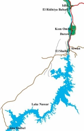
Cairo International Airport and our flight to Aswan. (See map showing flight from Cairo to Aswan and then map of route to the High Dam). The flight was booked solid so I did not have my usual aisle seat. This incon-venience, however, was offset by a great panoramic view of the pyramids of Giza from the air. It was striking how the site seemed to be a demarcation point between green vegetation and the sandy Sahara desert. After pointing out our luggage for the GCT staff at the airport, we were on our way to the Aswan High Dam, built in 1960, creating Lake Nasser (the world's largest artificial lake at the time). A symbol of Nasser's modernization, the dam forever changed the agricultural rhythms of Egypt.

Once subject to devastating Nile floods, Egyptian farmers looked to the Aswan High Dam as a way of improving their ability to control their crops. Aswan (means "trade") was the capital of the first Upper Egyptian nome and a base for military expeditions into Nubia, Sudan and Ethiopia. Right into Islamic times the city was visited by large caravans of camels, elephants laden with slaves, gold, ivory, spices, cloth and other exotic wares. The dam created one of the largest man made lakes in the world -- Lake Nasser. The dam contains 18 times the material used in the Great Pyramid of Cheops. About 35,000 people helped build this enormous structure and 451 of them died during its construction. Video and zoom lens not permitted. The dam has allowed land to be reclaimed from the desert and it generates hydroelectric power for industry. People along the Nile do not have to submit to flooding and in some areas grow two crops with irrigation. On the other hand, the dam prevents the flow of silt so crucial to the Nile Valley's fertility. Artificial fertilizers have polluted the mouth of the river so that shrimp beds and fishing grounds have almost disappeared.

Our bus stopped on a lookout situated on the High Dam. I took a video of the Nile River between the High Dam and the Low Dam. A security guard stopped my activity because only regular cameras could be used in this restricted zone – no camcorders, for whatever reason. On this photos of the High Dam, the created Lake Nasser is on the left.
At the western end of the dam there is a lotus-shaped tower, built to commemorate the Soviet Union’s support in building the dam.
As part of the Cold War struggle for influence in Africa the Soviet Union stepped in during 1958, and possibly a third of the cost of the dam was paid for as a long-term investment in the region. The Soviets also provided technicians and heavy machinery. Unfortunately, our buses did not stop here. I did photograph the tower later from the city of Aswan.
On the way to our ship we crossed over the Old Dam, built by the British in 1902. When it was built above the First Nile Cataract it was the largest of its kind in the world. It had to be raised twice to meet the demand. It greatly increased the amount of cultivable land and provided most of the country with hydroelectric power.
We boarded our riverboat to begin our River Cruise adventure. This river cruise ship, the Anuket, was our floating hotel for the next seven nights. Dan and I had Room 102, the same floor as the purser desk. The ornate and inviting dining room was just one floor down and a bountiful lunch was waiting for us. All 130 passengers on board were Grand Circlers.
In Egyptian mythology, Anuket (also spelled Anqet, and in Greek, Anukis) was originally the goddess of the Nile River, in areas such as Elephantine Island, at the start of the Nile's journey through Egypt, and in nearby regions of Nubia. Her temple was erected at the Island of Seheil. Since the flooding of the Nile is what nourishes the fields, she gained her name, which means embracer, in the sense of the Nile embracing the fields. Her titles were similarly appropriate to this, including nourisher of the fields, giver of life, and she who shoots forth (in reference to the flooding).
Since the god Khnum, and goddess Satis, were thought to be the gods of the source of the Nile, Anuket was viewed as their daughter. Being the deification of the Nile also lead to two tributaries of the Nile, in the region, being considered her arms. It also lead to her being associated with fast moving things, representing the river's flow, such as arrows, and the gazelle, which happens also to be an animal with a large presence at the Nile in this region. Thus in art, she was often depicted as a gazelle, or with a gazelle's head, sometimes having a headdress of feathers (thought by most Egyptologists to be a detail deriving from Nubia).
Ceremonially, when the Nile started its annual flood, the Festival of Anuket began, with people throwing coins, gold, jewelry, and precious gifts, into the river, in thanks for the life-giving water. The taboo, that was held in several parts of Egypt, on not eating fish, which were considered sacred, was lifted during this time.
Exclusive Discovery Series Event
Traditional felucca boats with their lateen (triangular) sails ply the water in profusion here. A felucca is a traditional wooden sailing boat used in protected waters
The rig consists of one or two lateen sails. They are usually able to board ten-some passengers and the crew consists of two or three people. Despite being made obsolete by motorboats and ferries, feluccas are still in active use as a means of transport in Nile-adjacent cities like Aswan or Luxor.
Before we could embark on this felucca adventure we all had to don life jackets that had been placed in our cabins. Once on board the felucca Attia and David were in control of our mission.
Guides for the four dotted teams. Attia is on the right.
Boarding feluccas.
On the hills of the opposite shore were the Tombs of the Nobles. These high cliffs are honeycombed with the tombs of dignitaries of ancient Yebu and date from the Old and Middle Kingdoms. David Nakamura (from El Cerrito, CA) sat opposite of me and was caught in the picture when a young Nubian boy pulled along side our ship with his small craft. The kid sang for tips before paddling off like a crocodile.
Feluccas were adrift everywhere, creating a beautiful sight suitable for an artistic painting.
Our sailing vessel cruised around Elephantine Island (Top of map. Note the Mausoleum of Aga Khan on the top left), resorting to tacking for the return trip back to the Anuket.
Elephantine Island or Yebu was probably named after the giant gray granite boulders, in the river around the island, which resembles a herd of elephants bathing. This ancient fortress of Egypt produced most of the pharaohs of the 5th dynasty. It was also the center of the cult of the ram-headed Khnum, creator of humankind and god of the cataracts who controlled the Nile's water level. Opposite Elephantine Island and on the west bank is the Mausoleum of Aga Khan. The 20th century Isma'ili Muslim leader (who died in 1957) wintered here. His wife oversaw theconstruction of the domed granite and sandstone mausoleum. Now in her 90s she still lives in the white villa below the mausoleum. The tomb is closed to visitors
This wonderful experience was followed with a dinner menu of fish served in the comfort of our lovely dinning room. The Anuket was a relatively new ship, having been built for Grand Circle in 2001, and the amenities were great.
Entertainment in the lounge that night at 8:45 pm consisted of a lively Nubian show. One aggressive performer sought out “volunteers” to participate in the action. Not all participants were eager to take center stage, but it turned out to be a fun evening.
DAY 8 Saturday, December 8 Aswan/Optional Abu Simbel Tour
Dan, the two Davids (Smith and Nakamura), and I had all signed up for the optional excursion to Abu Simbel. The price was $199 per person -- the cost included round trip airfare – and well worth the expenditure. Attia arranged for a 4:00 am wake-up call, but Dan and I got up a little earlier so breakfast would not beso rushed. Our bus left for the airport at 5:00 am. As was the case in all of our boarding (and un-boarding) on Egypt Air, we climbed up a ramp from the tarmac to the ship. The plane took us 40 minutes south to near the border of Sudan. Any mention of Sudan brought mental images of the genocide taking place there. When Attia was approached about the subject, he said the conflict was economic – between the oil-rich south and the food-rich north. When asked about the position of Egypt, he said the government just wanted political stability there. More could have been said on the subject.
Security was heavy with armed guards where we arrived at the ticket gate. We eagerly anticipated our first sight of Abu Simbel, the magnificent monuments carved into solid rock 3,000 years ago. In a monumental feat of modern engineering, these massive temples were moved to their present location when construction of the Aswan High Dam in 1960 created Lake Nasser and flooded their original location. This extraordinary operation to save one of the world’s greatest treasures took years and the efforts of an international team of engineers and archaeologists.
The two temples at Abu Simbel were built by Egypt’s great Pharaoh Ramses II (Egypt’s longest-ruling king) as a tribute to the deities and his favorite wife Nefertari. Although given the ego factor of Ramses II, it would be more accurate to say both monuments were built to honor him.
The first and larger monument was The Great Temple, dedicated to Ra, the sun god, and also really to Ramses himself. Guarding the entrance, the four famous colossal statues of Ramses II 60 feet high sit majestically, staring out across Lake Nasser. His queen and daughters were at his feet. The collapsed colossus of the Great Temple supposedly fell during an earthquake shortly after its construction. At the top of the temple façade is a row of baboon statues in adoring attitudes, said to welcome the rising sun. Above the entrance of the great Hypostyle Hall is the figure of the falcon-headed sun god Ra (Ra-Harakhty). Unfortunately the sun god has lost part of a leg and foot over time.

I walked around inside, passing through the Hypostyle Hall. The bas-reliefs on the walls of the hypostyle hall depict battle scenes in the military campaigns the ruler waged. Much of the sculpture is given to the Battle of Kadesh, on the Orontes River in present-day Syria, in which the Egyptian king fought against the Hittites. It was a great thrill to see the most famous relief showing the king on his chariot shooting arrows against his fleeing enemies. The inner part of the temple has the same triangular layout that most ancient Egyptian temples follow, with rooms decreasing in size from the entrance to the sanctuary. The innermost chamber is the Sacred Sanctuary, where the four gods of the Great Temple sit on their thrones carved in the back wall and wait for the dawn Ramses its in state flanked by the gods to whom the construction is dedicated. The colossal pillar statues along the left-hand wall bear the white crown of Upper Egypt, while those on the opposite side are wearing the double crown of Upper and Lower Egypt. I also moved the camcorder around to show the relationship of the monument to Lake Nasser. Originally built into the side of a mountain, the temple is now backed by an artificial mountain built to resemble the original location. The temple was constructed so that the rising sun shone between the statues of Ramses and into the inner recesses of the sanctuary on February 22nd and October 22nd. Modern engineers spent a full year calculating the new placement of the temple to reproduce this miracle. Today, as it has for millennia, the sun’s rays illuminate the holy statues for 20 minutes on those dates each year. At dawn sunlight is aligned to light the entire length of the temple, lighting up three of the four statues, but never touching that of Ptah, the god of darkness.

To the north of the main temple a smaller temple was built in honor of Ramses’ favorite wife, Nefertari, and the goddess Hathor. The rock-cut facade is decorated with two groups of colossi that are separated by the large gateway. The statues, slightly more than ten meters high, are of the king and his queen. On the other side of the portal are two statues of the king, wearing the white crown of Upper Egypt (south colossus) and the double crown (north colossus); statues of the queen and the king flank these. What is truly surprising is that for the only time in Egyptian art, the statues of the king and his consort are equal in size.
Traditionally, the statues of the queens stood next to those of the pharaoh, but were never taller than his knees. This exception to such a long-standing rule bears witness to the special importance attached to Nefertari by Rameses, who went to Abu Simbel with his beloved wife in the 24th year of his reign.
Nefertari’s temple has a single pillared hall, with carved Hathor heads atop the pillars. On the sides facing the center of the hypostyle, Ramses is shown smiting his enemies and offering before various gods, while Nefertari is shown, graceful and slender, with hands raised. Again, I turned toward Lake Nasser, this time to capture the wider view.
We headed back to the bus facing a gauntlet of vendors along the way. Security measures were followed as we boarded our plane ride to Aswan. The GCT buses met us at the Aswan Airport. We crossed the Old Dam to the east side of the Nile as we headed to our wonderful riverboat. Our relaxing evening included a Welcome Drink of cocktails in the lounge and a delicious Welcome Dinner that included eggplant and tender beef. After dinner Omar Dan tried on an Egyptian outfit in the Anuket gift shop. He looked a little like Lawrence of Arabia.
DAY 9 Sunday, December 10 Aswan/Kom Ombo/Edfu
Exclusive Discovery Series Event
A little change in the scheduled plan meant that our first order of business today would be a visit to the Papyrus Institute in Aswan to learn about the centuries-old technique of creating paper from papyrus.
Papyrus is an early form of thick paper-like material produced from the pith of the papyrus plant, wetland sedge that was once abundant in the Nile Delta of Egypt. Papyrus usually grows 5–9 feet tall, although some have reached as high as 15 feet. Moses’ mother made the boxlike float for her baby from the bulrushes. Papyrus is first known to have been used in ancient Egypt (at least as far back as the First dynasty), but it was also widely used throughout the Mediterranean region, as well as inland parts of Europe and southwest Asia. It was infinitely more easily handled than the baked clay tablets of Mesopotamia.
Our color-coded bus dropped us off at the Papyrus Institute where we were herded to a demonstration area. Attia introduced the session and then turned the program over to a local guide. She explained and demonstrated how a sheet of papyrus is made from the stem of the plant.
The outer rind was first stripped off, and the sticky fibrous inner pith is cut lengthwise into thin strips of about 40 cm long.
The strips were then placed side by side on a hard surface with their edges slightly overlapping, and then another layer of strips is laid on top at a right angle. While still moist, the two layers were hammered together, mashing the layers into a single sheet. The sheet was then dried under pressure. After drying, the sheet of papyrus was polished with some rounded object.
She held up the finished product – which was available in the shop.
In a dry climate like that of Egypt, papyrus is stable, formed as it is of highly rot-resistant cellulose; but storage in humid conditions can result in molds attacking and eventually destroying the material. In European conditions, papyrus seems only to have lasted a matter of decades; a 200–year-old papyrus was considered extraordinary. Imported papyrus that was once commonplace in Greece and Italy has since deteriorated beyond repair, but papyrus is still being found in Egypt. Extraordinary examples include the Elephantine papyri.
By 800 AD the use of parchment and vellum had replaced papyrus in many areas, though its use in Egypt continued until it was replaced by more inexpensive paper introduced by Arabs. The reasons for this switch include the significantly higher durability of the hide-derived materials, particularly in moist climates, and the fact that they can be manufactured anywhere. The latest certain dates for the use of papyrus are 1057 for a papal decree (typically conservative, all papal "bulls" were on papyrus until 1022) and 1087 for an Arabic document. Papyrus was used as late as the 1100s in the Byzantine Empire, but there are no known surviving examples. Although its uses had transferred to parchment, papyrus therefore just overlapped with the use of paper in Europe, which began in the 11th century.
The papyrus plants had other uses. The fibers, when twisted, made excellent cordage, and a good many of the vessels that sailed the ancient Mediterranean were rigged with ropes of Egyptian papyrus. Along the Nile, all small boats were made from bundles of bound papyrus reeds. In addition, papyrus served to make baskets, boxes, mats, sandals, sieves and stools. (Casson, Ancient Egypt, pp. 32-33).
This morning we also visited the lovely Philae Temple dedicated to Isis and perched majestically on an island. Because a boat ride was necessary, we all donned our orange life jackets. Our approach to the island presented a nice overview of the Philae Temple Complex.
We started our exploration with the Vestibule of Nectanebos (bottom of map ), a logical beginning point. It is also where boats usually land on the island. This temple dating to the 30th dynasty was dedicated to Nectanebos "Mother" Isis. Ptolemy II Philadelphos rebuilt the vestibule itself.
There are two rows of colonnades, which form a walkway to the first pylon of the Temple of Isis. I zeroed in the West Colonnade. My next shot was of the First Pylon, which is the newest part of Temple, in other words, the last part built. One part of the pylon represents the west bank of the Nile whereas the other side represents the east bank. The entrance, of course, represents the Nile itself.
The large figure with the outstretched arm carved on the right pylon is of the king Ptolemy XI. Because of the pylon’s prominence, it was the ideal setting for display and propaganda— more often centering around the pharaoh who built the temple rather than on the god or goddess.
We entered the Portal of Nectanebos that led to the Inner Court. Note the columns in later papyrus style and the Second Pylon ahead.
We moved through the Second Pylon to a Hypostyle hall with 10 ornate pillars.
Finally we reached the oldest part (first built) the Shrine Room, or as Attia called it, the Holy of Holies. On the wall were portrayals of Ptolemy II Philadelphos and Isis. Christians who wanted to block out old deities damaged some of the inscriptions and figures, such as Isis.
As we headed back, along the side of the temple precinct we observed Trajan’s kiosk. This beautiful building was where the sacred barge with the statue of Isis landed during its annual precession down the river. The kiosk, rebuilt by the Roman emperor Trajan, consists of 14 columns with screen walls that are decorated with scenes of Trajan making offerings to Isis, Osiris and Horus. From this spot I took a video of the nearby island from which the temple originated.
This exquisite temple complex spent periods of time underwater after the Old Dam was first built, and the building of the High Dam threatened it permanently, as the rising waters of Lake Nasser almost completely submerged the original Philae Island. A coffer was built around the island, water was pumped out, and the temple was painstakingly dismantled by UNESCO and reassembled on Agilika Island where we see it today.
We boarded our boat, reached the mainland and shed our life jackets. We had lunch aboard ship and cruised the Nile to the Temple of Kom Ombo. See map. As we cruised the river to our destination I taped the bucolic scenery along the banks from our cabin.
The Town of Kom Ombo is located about 41 miles south of Idfu. Kom Ombo is the ancient site of Ombos, which is from the ancient Egyptian word 'nubt', which means 'City of Gold'. It has been occupied since prehistoric times. In ancient Egypt, the city was important to the caravan routes from Nubia and various gold mines. The local industry is primarily agriculture, including irrigated sugar cane and corn. Besides the native Egyptians, there is a large population of Nubians who were displaced from their land when Lake Nasser was created.

Greco-Roman style temple (actually two temples) is unique, as it is Egypt’s only double temple —dedicated to both Sobek, the crocodile god, and Horus, the great, winged solar disk falcon-headed sky god. Everything here is doubled and perfectly symmetrical along a central axis—twin entrances, twin courts, and twin colonnades. We started at the dual entrance on the south side and worked our way towards the dual sanctuaries. I taped inscriptions starting with Horus the falcon headed god and then Sobek the crocodile god. Another video I took shows Ptolemy with both the falcon headed god and the crocodile headed god. As elsewhere in Egypt, desecration of deity figures was prevalent.

Attia led us to an enclosure wall surrounding the sanctuaries, one built for the commoners who could not enter the temple. Here Attia pointed out a famous medical relief. The lady in seated position is actually giving birth to a baby. Adjacent to this figure are surgical inscriptions and prescriptions. Last, but not least, we entered the Holy of Holies. By now the sun had now gone down and artificial lighting lighted up all the buildings. Interesting effect.
South of the main temple is the Roman Chapel of Hathor, dedicated to the wife of Horus, which is used to store a collection of mummified crocodiles dug up from a nearby sacred animal cemetery. It was too dark for my camcorder to record.
When we returned to our docking area, David Smith began negotiating prices with a vendor for an ornate cane. After intense haggling (which is sporting fun here) he finally reached a compromise. I purchased a colorful skull hat at the same outing.
For dinner GCT featured an Egyptian Dinner buffet where everyone was invited to dress Egyptian. It seemed like everyone got into this so I strolled around the dinning room with my camcorder.
Later that night we were treated to a Galabeya Party -- music was performed by authentic Egyptian
instruments.
DAY 10 Monday, December 10 Edfu/Esna/Luxor
This morning, at 5:30 am, we set sail to Edfu. Breakfast was at 7. The morning was at leisure so I
enjoyed the Nile river views from our full-length floor to ceiling cabin window.
The land by the Nile produces rice, maize, wheat vegetables, and fruit. Here, in contrast to the desert, vegetation is abundant: date palms, tamarisks, mimosa, eucalyptus, cypress, and jasmine. Cotton forms the main cash crop.
We disembarked for a visit to Edfu’s Temple of Horus. This temple was buried under sand and silt for nearly two thousand years, which helps account for its preserved condition.
As with other temples, we started by viewing the First Pylons, which were split to represent the banks of the Nile. Note floor plan above right.
Horus (with the falcon head) and Ptolemy were prominently displayed.
We entered into the Courtyard sur-rounded on three sides by 38 columns. At the far end was a statue of Horus guarding the entrance at the second pylon. We entered into the first Hypostyle Hall with the 12 enormous hypostyle columns. The second Hypostyle Hall is smaller, but also has large columns. This led us to the Conference Hall, which in turn led to the Sanctuary.
Carvings of Horus were disfigured entirely, but most disfiguration of figures was of arms and leg, presumably as an easier way to render them helpless. Attia pointed out examples where genitals were chipped away. He blamed the “pious Christians” for this desecration. When I mentioned to Attia that the Lonely Planet Guidebook notedthat after the Christian period, Muslims desecrated monuments in turn. He said no, that Muslims would not do that.
Notice the disfiguration of the heads and arms.
We had a great dinner back at the ship. I thought the dessert merited a picture. The ship’s crew presented an entertainment skit in the lounge. Afterwards they led a join-in “snake dance” around the lounge. The movie shown on cabin TV tonight was “Death on the Nile” but we did not stay up to watch it.
DAY 11 Tuesday Luxor/Valley of the Kings & Queens
After an early 6 am breakfast, we departed at 7:30 am for the west bank of the Nile (see map), the hilly area that was known the Necropolis of Thebes. From the 18th to the 20th Dynasty, the Memphis area and pyramid-style tombs were abandoned in favor of the West Bank of the Nile in Thebes.
As we headed for the Valley of the Kings we passed the temple of Queen Hatshepsut in Deir el-Bahari.
I really wanted to visit this site, but had to settle with a view from the bus. (Picture of it is on the tape). It used to be on the itinerary for GCT, but they dropped it for another site. Possibly this was because of the massacre of tourists here by terrorists a few years ago. It was a sight to behold. Rising out of the desert plain, in a series of terraces, the Mortuary Temple of the queen merges with the sheer limestone cliffs of the Theban Mountains. It wasn't excavated until 1896 and is still in the process of being restored. The worst damage to the site was caused by Hatshepsut's successor, Tuthmosis III.
Attia did later give us information about Queen Hatshepsut, the only female Pharaoh. I added a few notes here: The following is from touregypt.net: “The Queen Who Would Be King - 1473-1458 B.C.”
Hatshepsut was the daughter of the Pharaoh Tuthmosis I and Queen Ahmose, both of royal lineages. She was married to her own half-brother, Tuthmosis II, with whom she reined for some 14 years. Realizing his sister-wife's ambitious nature, Tuthmosis II declared his son by the harem girl Isis to be his heir, but when the young Tuthmosis III came to the throne, Hatshepsut became regent and promptly usurped his position as ruler. To support her cause she claimed the God Amon-Ra spoke, saying, "Welcome my sweet daughter, my favorite, the king of Upper and Lower Egypt, Thou art the King, taking possession of the Two Lands."
She dressed as a king, even wearing a false beard and the Egyptian people seem to have accepted this unprecedented behavior. Hatshepsut had herself portrayed in the royal headdress, sometimes as a woman with prominent breasts but more often as male in body as well as costume. Hatshepsut accomplished what no woman had before her. She ruled the most powerful, advanced civilization in the world. Her consort and true love was her advisor, Senmut. She remained in power for twenty years during which time the Egyptian economy flourished.
She built magnificent temples as well as restoring many of the old ones, most notably the great mortuary temple at Deir al-Bahari. The mortuary temple of Queen Hatshepsut is one of the most dramatically situated in the world. Hatshepsut disappeared in 1458 B.C. when Thutmose III, wishing to reclaim the throne, led a revolt. Actually, recent medical technology has determined her mummy (long lost) and has confirmed she died a natural death (gum disease) Thutmose III had her shrines, statues and reliefs mutilated to establish royal legitimacy for his son.
We continued on to visit the Valley of the Kings, with its many tombs chiseled deep into the cliff sides. Several great leaders as well as many less important rulers are buried here, and more tombs are being discovered even today.
The buses dropped us off at the main parking lot. Attia purchased tickets for us to visit our choice of any three tombs (except for King Tut’s tomb).
I chose the Attia recommended trio of Ramses III (containing some of the best-preserved and most colorful hieroglyphs), Ramses IX and Ramses IV, in that order. (See map locator on tape) We boarded shuttle buses to take us out to the main tomb area.
I was struck with how well the artwork was preserved on the walls. Understandably, most wall decorations were covered with glass as a protective measure.
Security was tight here. The government of Egypt wants nothing to disrupt the tourist industry.
Those who wished to visit the tomb where Howard Carter discovered the treasures of Tutankhamen, had to purchase a special ticket. Dan was in that number which chose to take in this extra tomb. Of the royal tombs in the Valley of the Kings, only that of Tutankhamen miraculously escaped robbery.
After we left the tombs, we shortly came upon the house of Howard Carter who discover Tut’s tomb in 1922. We did not stop here, but I taped the structure from the bus. It’s worth recalling his memorable words: "At first I could see nothing, the hot air escaping from the chamber causing the candle flames to flicker, but presently, as my eyes grew accustomed to the light, details of the room within emerged slowly from the mist, strange animals, statues and gold - everywhere the glint of gold. For the moment - an eternity it must have seemed to the others standing by - I was dumb with amazement, and when Lord Carnarvon, unable to stand the suspense any longer, inquired anxiously, 'Can you see anything?' it was all I could do to get out the words, "Yes, wonderful things."'
Travel guides like to include stops at establishments that provide brief demonstrations followed by a visit to a salesroom. Commissions reward those who supply customers. Some tourists see these stops as plus; others do not. Today we took in an alabaster store that was somewhat interesting. Some of us are not that familiar with alabaster and it was used in ancient times and later mosques.
The Valley of the Queens was next on the agenda. As we headed out we could see the Tombs of the Notables on the right hand side. Massive numbers of tombs belonging to priests, officials and other private individuals dot the hillside. We passed the ruins of the Ramesseum on our left hand side, but could only observe them from the bus.
Rameses II was a pharaoh of the 19th dynasty Egypt. He ruled for 66 years and 2 months during the 13th century BC, the apogee of Ancient Egypt's power and glory. This extraordinarily long reign, the wealth available in the state coffers, and, undeniably, the pharaoh's personal vanity meant that Rameses, of all the ancient rulers, left what is perhaps the most indelible mark on the country.
Surviving records indicate that work on this project began shortly after the start of his reign and continued for 20 years. Unlike the massive stone temples that Rameses ordered carved from the face of the Nubian mountains at Abu Simbel, the inexorable passage of three millennia was not kind to his "temple of a million years" at Thebes. This was mostly due to its location on the very edge of the Nile floodplain, with the annual inundation gradually undermining the foundations of this temple.
We arrived at the Valley of the Queens.
Attia purchased tickets for us to enter the tomb of a son of Ramses III. Not only queens were buried here but also their children. We also were permitted to walk into the tomb of a Queen of Ramses III, Queen Titi. Queen of Rameses III was Queen Titi, who was buried in QV52 in the Valley of the Queens. Though this tomb is large, it lacks any proper indication of her exact royal status. However, her titles suggest that she was possibly a daughter, and later a wife of Rameses III who probably outlived him. Her title as "Mistress of the Two Lands" appears some 43 times within this tomb, and she is listed as "Chief Royal Wife" 33 times. Other titles include "King's Daughter, "King's Beloved Daughter of his Body", "His Beloved Daughter" and "King's Sister". She is also called "King's Mother" eight times and her son might have been Rameses IV.

The Tomb of Nefertari ( right) is hailed as the finest tomb in the Theban necropolis, and all of Egypt for that matter. It was opened to the public in 1995 but was not accessible while we were here. It was located directly across from the tombs we visited. We saw only the entrance.
One of five wives of Rameses II, Nefertari was his favorite and the tomb here has been is said to be one of the most beautiful in Egypt. The tomb is completely painted with scenes though out. In most of these, Nefertari, known as 'the most beautiful of them', is accompanied by gods.
After leaving the fabled valley, we stopped at the pair of massive statues of Amenhophis, known as the Colossi of Memnon.
Amenhotep III (18th Dynasty) built a mortuary temple in Thebes that was guarded by two gigantic statues on the outer gates. All that remains now are the 23-meter (75 ft) high, one thousand ton statues of Amenhotep III. Though damaged by nature and ancient tourists, the statues are still impressive. Ancient Egyptians called the southern of the two statues "Ruler of Rulers". The statues are made from carved blocks of quartzite quarried either at Giza or Gebel es-Silsila. The Northern statue depicts Amenhotep III with his mother, Mutemwia, while the southern statue is of Amenhotep III with his wife, Tiy and one of his daughters.
Due to an earthquake in 27 BC, these statues became known for a bell like tone that usually occurred in the morning due to rising temperatures and humidity. Thus they were equated by the early Greek travelers with the figure of Memnon, the son of Aurora who's mother, Eos, was the goddess of dawn. To be granted a song meant that you were very much in favor of the gods. Visitors came from miles around to hear the music, including Emperor Hadrian, in 130 A.D. The Roman emperor Septimius Severus, seeking to repair the statues in 199 AD, inadvertently silenced them forever.
We returned the riverboat for lunch and then at 4:30 pm. set off for the nearby Luxor Temple. Attia said that after the tour those who wish return bus transportation should meet at a designated spot near the temple entrance; and those who wish to return to the boat on their own are free to do so. We started at the northern entrance (top of map below) where a causeway lined by sphinxes linked it to Karnak.
The temple properly begins with the 79 ft high First Pylon, built by Rameses II. Six colossal statues of Rameses – four seated, and two standing originally flanked this main entrance to the temple complex – but only two (both seated) have survived. We saw an 82 ft tall pink granite obelisk: it is one of a matching pair. The other was taken to Paris in 1835 where it now stands in the center of the Place de la Concorde.
Attia pointed out (photo right) a carving that symbolizedthe union of northern and southern Egypt. The strip though the center was a symbol of the Nile. Note the papyrus on the left and the lotus on the right. I centered in on a statue of Ramses II next to the entrance. The pylon was decorated with scenes of Ramese's military triumphs (particularly the Battle of Kadesh); later pharaohs, particularly those of the Nubian 25th dynasty, also recorded their victories there.
The pylon gateway leads into a peristyle courtyard, also built by Rameses II. To our left is the mosque of Abu el Hagag. At the time it was built it was situated at 19th century ground level.
Actually the mosque was built on top of a Coptic church that had been built on this temple site.
Columns surrounded the rest of Ramses II Courtyard. After the peristyle courtyard comes the processional colonnade built by Amenhotep III – a 328 ft corridor lined by 14 papyrus-capital columns.
Beyond the colonnade is a peristyle courtyard, which also dates back to Amenhotep's original construction. The best-preserved columns are on the eastern side. The southern side of this courtyard is made up of a 32-column hypostyle court that leads into the dark inner sanctums of the temple.
We returned to the entrance gate, caught our bus and headed toward the ship. Through the front window I captured a horse carriage clopping down the street. Tired, but content, Circlers filed into the docked Anuket.
Entertainment tonight was at 8:30 pm: Whirling Dervish in the Lounge. The male entertainers kept our attention both from the music aspect and the endless whirls of a costumed performer. The show time concluded with two men in a horse outfit carousing among the guests, often making mock amorous overtures. It was all done as good fun.
Whirling Dervish performance may be seen anywhere in the world, but the chances of doing so vastly improve in Egypt. Not only is there the dervish theater located near the Khan el-Khalili, but many belly dancing shows in nightclubs and dinner boats will also include Whirling Dervish. But most people who attend such performances have little idea of the nature of this dance, which is called the sema. It is a rare occurrence of religious ceremony transcending into performing art.
The Sufi, a rather mystic order of the Islamic faith, has performed the dance for over 700 years. But in fact, many of the dervish performers one sees in Egypt and elsewhere are performers and not truly of the Sufi order. There are some traveling Sufi, particularly from the Mevlana sec t and they perform the dance in a more or less traditional manner. When they extend their arms, the right palm faces up and the left palm faces down. They believe that energy from above enters through the right palm, passes through their body and passes through their left palm and into the Earth But most of the more colorful performances are entertainers. The performer "turns" or whirls endlessly while manipulating skirts in a colorful display.
When we retired to our cabin a towel “cobra” was waiting for us on our bed.
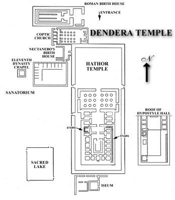
DAY 12 Wednesday, December 12 Dendera / Luxor
Today Dan decided to do a little shopping in Luxor so he stopped at the Commercial National Bank of Luxor and withdrew from his money at Bank Midwest account Egyptian pounds worth $181.63.
We had our usual comprehensive breakfast starting at 6:30 am. Two GCT buses were lined up at 7:30 am to take us to Dendera. See map Luxor to Dendera. Before we could hit the highway we had to gather with other tour buses and vans so that we could leave together as a caravan. The area we were going into was not as secure as at previous sites.
At the appointed time, all the vehicles left Luxor. All along the route armed security agents were stationed to protect our caravan. All regular traffic was forced to stop at intersections until the caravan had passed. When our buses reached these intersections we never slowed down, but simply took the other lane around the stopped vehicles.
At these intersections armed guards were also stationed in little elevated cubicles.
These same safeguards were in place for the return trip. Talk about security! The government of Egypt does not want any incidents that might hinder tourism because tourism if extremely vital to their economy.
We arrived at Dentera.
We examined what has remained of the First Pylon – the immense gateway to the Temple. Attia has us concentrate on a pylon carving, one of Hathor and Horus.
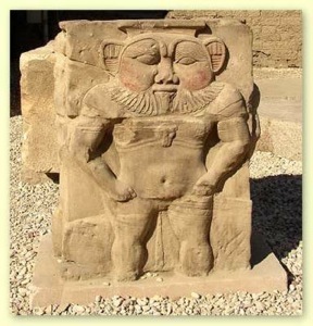
Just inside the entrance was a statue of Bes, patron saint of childbirth. This ugly little demigod was thought to always be around during festivities.
The main temple has an imposing pylon shaped façade constructed as a low screen wall divided by six massive Hathor-headed columns and a huge curved cornice with a winged sun disc over the entrance. The next room was the Inner Hypostyle Hall with massive Hathor-headed columns. Hathor is shown in her human form with cow’s ears at the head of the 18 columns in the hypostyle hall.
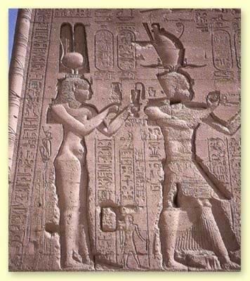
From here we entered the Sanctuary – the Holy of Holies. An inscription on the wall here portrayed Ptolemy knocking on the door for Hathor. The next drawing shows him receiving the key for afterlife. The opposite wall had a picture of a boat ransferring Ptolemy to the afterlife. From the sanctuary we moved over to the New Year Chapel where rituals were performed. The ceiling shows Nut giving birth to the sun.
Mission on the ground floor completed, we headed to the second level -- up a narrow stairway between walls covered with inscriptions. The stairs were really more like a ramp because the steps were so worn away. A group of touring students was out on the open-aired roof. In one corner was an open-air kiosk that had been the focus of the New Year celebrations. We walked down a different narrow stairway back to the ground level.
Attia left us here to be on our own. He suggested we take a look at an inscription of Cleopatra on the back exterior wall. We found carvings depicting Cleopatra VII and her son, Ptolemy XV Philopator Philometor Caesarion, fathered by Julius Caesar.
I continued on around the outside of the temple, stopping only to video the Sacred Lake, which was now filled with lush vegetation. In the historic past this lake was used for ritual washing.
The trip back to Luxor entailed the same security measures as earlier: buses and vans lined up in a convoy, intersections were secured and non-stop travel by our caravan. I taped these measures as well as local scenery along the highway.
After lunch on the Anuket, we loaded up in our buses and headed for Karnak Temple. We were now to explore Karnak’s huge complex of shrines, built and enlarged over a period of 1,300 years. The key architect was Rameses II and many of the inscriptions are propaganda pieces depicting his “victory” over the Hittites. The ancient Egyptians called the enormous temple complex of Karnak “the most perfect of places,” and today it is one of the most fascinating sites in Egypt. The huge Hypostyle Hall, with its outer walls decorated with battle scenes, is a grand architectural marvel large enough to enclose the Cathedral of Notre Dame.
Karnak ruins are the most extensive group of surviving ancient buildings in the world. Karnak represents the creative peak of the brilliant New Kingdom, whose pharaohs ruled Egypt from Thebes for more than 500 years. Most of the buildings date from about 1560-1090 B, C, and are temples to Amun.
From the northern axis entrance we passed down the processional avenue of ram-headed sphinxes, which once led to the Nile, to the massive 1st pylon. Each ram is holding a statue of the king, Rameses II, in its paws.
The massive First Pylon (above) is unfinished but its height is still pretty impressive.
We entered the gateway to the Great Court, the largest area of the Karnak complex. In the center of the Great Court is the one remaining column of the Kiosk of the Nubian Pharaoh Taharqa. Attia says we are fortunate that the First Pylon was not finished because the building ramp on the interior wall is still there. Ramps were used to raise the high construction blocks. As the ramps were removed to lower levels, inscription carvers working on the pylon could use them. Attia also pointed out columns in the inner court that were in rough form. This gave evidence to what the columns look like before being rounded off.

Beyond the 2nd pylon is the Great Hypostyle Hall (above), an unforgettable forest of 134 towering stone papyrus-shaped pillars. The famous hypostyle hall 54,000 square feet with its 134 columns is still the largest room of any religious building in the world. The columns were built one layer at a time. After a layer had been laid, sand was placed around the stones to allow the next layer to be built. This was repeated until all the columns were completed. All the sand between the columns was then removed.
Then we approached the Sanctuary (Holy of Holies), people were coming out of the small building. This is a granite barque shrine, which was built by the Greeks to replace an earlier shrine of Hatshepsut’s successor, Tuthmose III. Attia took us to a nearby room where Tuthmosis III had disfigured figures of Hatshepsut in his attempt to eradicate or hide all signs of his stepmother, Queen Hatshepsut (ruled 1500-1480 B.C.). We had touched on this relationship earlier on the trip. The reliefs survived because Tuthmosis III chose to cover her structures rather than to destroy them.
Our next area of study concerned the two magnificent Obelisks of Hatshepsut (above). The first on the video is the tallest (nearly 100 feet high) obelisk in Egypt—raised by Queen Hatshepsut in honor of Amun the god of fertility and growth. Added note: The tallest obelisk in the world is that of Tuthmosis III and IV. I saw that one standing outside St. John's Lateran in Rome.
Just outside the temple, on the northwest side of the Sacred Lake is the top half of Hatshepsut's fallen obelisk (right). Attia went to great lengths to explain how these obelisks were quarried, carved with inscriptions and moved to their destinations. Hewn out of a single block of stone, they could reach as high as 30 meters or more and might weigh as much as several dozen tons. Their quarrying, transport and erection were an enormous undertaking and pharaohs did not hesitate to advertise the fact.
Nearby the fallen obelisk was a monument (above) featuring a giant scarab. The scarab was an Egyptian dung beetle regarded as sacred and the symbol of rebirth. People were running around the monument to “win favors”.
To the east of the 7th and 8th pylons is the Sacred Lake, where the priests of Amun purified themselves before performing ceremonies in the temple. Most temples had a Sacred Lake within the precinct, used for beauty purposes and to provide fresh water for the temple. They were generally rectangular, lined with stone, and had steps leading down to the water. We re-boarded our vessel. At 6:00 pm we set sail for Esna. A treasure hunt was held in the lounge, but some of us skipped
this to catch up on our journals or to relax.
DAY 13 Thursday, December 13 The Nile River to Aswan
We set sail for Aswan at 6:30 am. Some of us slept in a little for a later breakfast – breakfast buffet was held until 9:30 am.
Exclusive Discovery Series Event
This was a day to sit out on deck in the sunshine and to drink in the passing vistas of everyday Nile River life or to take afternoon tea in the lounge.
Dan shed his shirt to bask in the December sun. Temperatures were in the usual 70s.
Exclusive Discovery Series Event
At 5:30 pm, we could get an introduction to hieroglyphics and Arabic languages. One of the other “dot” guides gave an interesting presentation on hieroglyphics. He started by showing how the interpretation of hieroglyphics symbols became possible after the discovery of the Rosetta Stone. After printing the hieroglyphics for Ptolemy (which was translated from two languages, one being Greek) he showed how matching those symbols in the word Cleopatra could increase the known symbols. Another “dot” guide introduced us to the Arab language and numerals. He explained how the Arabic numerals themselves indicated quantity by the number of angles in the symbols.
At 7 pm we indulged in farewell drinks and finger snacks, followed by the Farewell Dinner and baked Alaska ceremony.
DAY 14 Friday, December 14 Cairo
After breakfast, we transferred to the airport for an uneventful flight on Egypt Air back to Cairo. We checked into the Marriott and were at leisure until the evening. Dan and I had the sandwich (sub) special at the bakery shop in the Palace. Later, Dan joined some fellow travelers for dinner pizza. Fred held out for a possible special evening outing.
Around 5:30 we gathered for Farewell Drinks in the elegant Salon Eugenie of the Palace. Here we
could bid Attia farewell and give him his gratuity. David Smith and I decided to head over to riverfront Maxim for dinner cruise on the Nile with live entertainment.
David and Fred took a dinner cruise on te Nile.Lady singers sang for us as we ate a delicious dinner and fancy dessert. A Whirling Dervish show followed and the dancer finished by walking around visiting the guests. Meanwhile we sailed on the Nile. Lights glimmered on the water from passing ships. The entertainment closed with an energetic belly dancer. David Smith kindly picked up the tab, which proved to be quite a generous offer.
DAY 15 Saturday, December 15 Flights Home
In the morning our bus driver transferred us to the airport for our flight back to the States on Egypt Air. Our flight took off at 10:10 am. We arrive at JFK 3:15 pm After customs we took a free 5-minute shuttle to Comfort Inn JFK airport (Jamaica NY) reserved on Discover but paid on Visa. Actual charge with phone call to Sue was $149.97
DAY 16 Sunday, December 16
The included breakfast at Comfort Inn wasn’t bad. Our flight Northwest 315 departed at 11:24 am and arrived MSP at 1:31 pm. Sue met us at the airport just after we claimed our luggage. Good timing. We were hungry, but we survived until Emma Krumbees where we satisfied ourselves with their wonderful BarBQ rib plate.
THE TRIP COULD NOT HAVE BEEN BETTER -- GREAT TOURS AND SITES, TERRIFIC ACCOMMODATIONS ----- AND WONDERFUL PEOPLE