A nice full breakfast at the Burlington prepared us for a busy day. This morning we had an interesting drive to Boyne Valley. We crossed the Boyne River over this arched stone bridge. On the other side of the river was this defensive castle which has an interesting history.


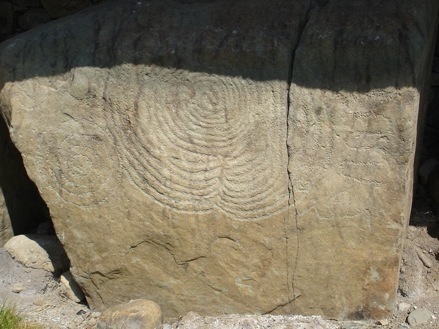
How they transported the stone remains a mystery. The geometric designs on some stones at the center of the burial chamber continue to baffle experts. A well-informed guide narrated the entire history of the site. Videotape includes narration by the guide
We drove on to Longford where we had lunch at the Cunyngham Arms Inn, in a very quaint dining room with a fireplace. Leaving Longford we passed by Longford Castle for a quick look.


On the video is the grave of Yeats, his grandfather’s church, the interior of the church (including the art work behind the altar), the round tower, and the cross with engraved Bible stories on it.


We then drove on to Sligo, the ”Heart of Yeats Country,” situated between Lough Gill and the ocean. Street scene in Sligo. Just before we arrived in Balleyshannon, we passed the major military installation of Ireland, very near our B&B, and only 3 miles from the border of Northern Ireland.
The army of the Republic is a volunteer force — there is no compulsory military service in Ireland — which has shown its mettle in United Nations peacekeeping forces in many parts of the world. Baedeker, Ireland, p. 18
I took beautiful views from our B&B. Everything seemed so peaceful, but while we were here some cars were firebombed in Northern Ireland.
July 3, Monday
Great B&B breakfast. Today’s touring took us through the rugged wilds of County Donegal. County Donegal is among the wildest, most rugged beautiful places in the world, says Fodor’s Guide. Tucked into the folds of the Northwest’s hills, modest little market towns and unpretentious villages with muddy streets go about their business quietly. In the squelchy peat bogs, cutters working with long shovels pause to watch you drive past. As you drive along country lanes, you may find a whitewashed cottage, with children playing outside, a shepherd leading his flock, or a bicycle-riding farmer wobbling along in the middle of the road.

To harvest a bog, the cutting machine scoops up soggy peat from a bank several feet high, chews and shapes the peat into neat bricks called sods, and drops them from its 180 foot arm in long rows to dry. Bogland covers about one-seventh of Ireland. “Discovering Britain and Ireland,” (National Geographic, 1985) pp. 384-5
Our trip today would include Ballybofey and Letterkenny to Ardara, one of the county’s most scenic villages, and then back to Donegal Town. Before reaching Letterkenny we saw some beautiful mountain scenery and large peat bogs. Letterkenny, the northernmost site on our Irish tour. Letterkenny, the county’s largest town, has a population of 6500. For the rest, you’ll discover almost nothing but scenery — unkempt, windswept, sheep grazed grasses on mountain slopes.

As we continued our drive through Donegal County we passed by sites where fir trees were flourishing. These trees were planted on bog areas where the peat had been stripped away. Because the new surface has a high acid content, it is quite suitable for evergreens. This now contributes to a thriving lumber industry in Ireland. Tommy had the bus stopped by a peat bog so we could see how it was “mined” and stacked out dry. The rows of plastic bags that can be seen around the bogs have been placed there so that the peat can be easily carried.
Before reaching Ardara we made a brief stop at Lough (lake) Finn. And then Ardara: Ardara (accent on the last a) is an unpretentious, old fashion hamlet of low, pale cottages among the green and brown hills; fortuitously situated at the head of a lovely ocean inlet. For centuries Ardara has been an important wool-trading center. Though the cloth fairs have died out, cottage workers in the surrounding countryside still provide Ardara (and County Donegal) with very high-quality handwoven cloths.


After dinner at the guesthouse in Balleyshannon, Tommy took us out to Kelly’s Kosy Korner in Balleyshannon for a night of Irish singing merriment, and Guinness. Most of the songs were sung by an Irish lass (oldest of 14 children) who played an accordion. Among the songs were:
My Wild Irish Rose & When Irish Eyes Are Smiling
What Ireland Means to & Me When You and I Were Young, Maggie
It’s a Long Way to Tipperary I& If You’re Irish
It’s an Irish Lullaby & The Soldier’s Song
When The Soldier’s Song was sung, all the Irish (including our guide, Tommy) had tears in their eyes. This was the rally song of the IRA. Very emotional. Our fellow traveler, Ruth, had requested it.
The National Anthem of Ireland is the Soldier’s Song — written in 1907 by Peadar Kearney, with music by Patrick Heeney and Peadar Kearney — a marching song harking back to the fight for independence. Baedeker, Ireland, p. 18
July 4, Tuesday
Our first stop after leaving Balleyshannon was Innisfree (pronounced Inish Free), the “Lake Isle” around which Yeats weaved his enticing imagery:
”I will arise and go now, and go to Innisfree...
And live alone, in the bee-loud glade...
I hear lake water lapping, with low sounds by the shore;
While I stand on the roadway, or on the pavements grey,
I hear it in the deep heart’s core”
We saw the little tree-covered island just offshore.
Our next stop was at the Holy Well and Shrine. Here Catholic priests hid after the Penal Laws were passed outlawing their ministry.
When Catholic worship was forbidden, Mass continued to be celebrated in secret in the open air at ”Mass Rocks” in remote places like this. Those who wanted to become priests had to seek training and ordination abroad, mainly in France and Spain. Grottoes were often set up at crossroads or in natural rock formations. There were many holy wells surrounded by a wall, round which rosaries have been deposited.


The founders of Galway were Anglo-Normans who arrived in the mid-13th century and fortified their settlement against the “native Irish,” as local chieftains were called. Galway became known as the City of Tribes because of the dominant role in public and commercial life of the 14 families who founded it. Their names are still common in Galway and elsewhere in Ireland: and recur regularly in any account of Irish history and culture: Athy, Blake, Bodkin, Browne, D’Arcy, Dean, Font, French, Kirwan, Joyce, Lynch, Morris, Martin, and Skerret
The patron saint of Galway is Brendan. The Irish believe that Brendan discovered the New World centuries before Christopher Columbus. Naturally, it’s said that Brendan sailed from Galway.
Annette and I started off our walk at one of the Gates in the city that were taken from buildings of the early founders — this one from the Browne family. We ate lunch on a park bench at the John F. Kennedy Memorial Park. Central to the park was a large steel sculpture of a Galway Hooker. We then walked over to a new mall, which incorporated parts of the old City Wall within it. Back on the streets of Galway we saw street performers (buskers), sellers of craft wares, and a lot of pedestrian traffic. On this busy corner was located the Lynch Castle:

Since Galway is famous for its sweaters we purchased one here for Annette, and then headed back to Kennedy Park to rejoin our group.
After a short drive to the waterfront, we climbed aboard the ”Corrib Princess” for a scenic river cruise.

The river cruise lasted one and a half hours and traveled five miles up the Corrib River and about three and a half miles around Lough Corrib. River Corrib is famous for its large population of mute swans.
From the dock area we could see Galway Cathedral (which we later visited) and portions of the old Galway stone bridge. Along the river was University College (just beyond the young lady standing by the boat railing);
This is part of the National University of Ireland, in which much of its teaching is in Irish. Our guide Tommy, who could speak the Celtic (Gaelic) language, said it is required of all students, along with English, until grade 12. But only 4% of the Irish people use it as a working language. The government promotes the language, not only in schools, but requires that all road signs be printed in both languages, and that stipulated time spots on TV and radio must be in Irish.


On the city side of the bridge was a marker with this inscription: ”On these shores around 1477 the Genoese sailor Christoforo Columbo found sure signs of lands beyond the Atlantic”. The main purpose of our walk was to see St. Nicholas Church (Church of Ireland), which is alleged to have a tie with Columbus.

That evening we stayed at our B&B in Galway.
July 5, Wednesday

Our first stop on the peninsula was at Spiddal where we had an opportunity to see the stony surface of the land and the many walls made out of rocks.
Shortly we would arrive at the Connemara Marble Factory where we had a chance to see slabs of green marble unique to the area. Further on we saw huge peat bogs with rows of peat stacked out to dry. Further along the road was a true-to-scale replica of a Crannough dwelling. These floating islands were used around 500B.C. (according to Robin Krause, Ireland, p. 37). The actual ruins are no longer around because the construction material was not long lasting.
For lunch we stopped at a quaint village of Clifden, population 1,381. After lunch we had free time to see the village and visit St. Joseph’s Catholic Church up on a hill. Clifden is famous as the European initial location site of the transatlantic cable project of Marconi. There is a Marconi Pub in town and posters celebrating the anniversary of the event.

Cathedral, built by Mitchell Henry on the abbey grounds. The abbey sells sweaters, gifts, and general craft items.
We returned to our lovely B&B in Galway. Like so many of our home-stays, the yard was adorned with flowers. Naturally, more video of flowers, this time still wet from raindrops.
July 6, Thursday
After a full B&B breakfast, we headed through Galway City on the way to the countryside of County Clare. At Galway we managed to get our last view of the Spanish Arch on the Corrib River.
Spanish Arch. The best-known landmark in Galway, the arch was built in 1594 as an addition to the Old Town wall to provide protection for the docked Spanish ships unloading their wines nearby.


Unfortunately, the rain and mountain mists prevented us from seeing very much. We had to satisfy ourselves with the sound of the pounding waves. At Lahinch we did stop along the ocean for a break and a chance to watch some surfers.

Six of us were chosen to sit at the head table. Two of our friends were then chosen to be Lord and Lady MacNamera. Ironically, our friends had the O’Brian name. You may recall that in real history the O’Brians of Bunratty Castle were the bitter rivals of the MacNameras. The banquet went on anyway. One of our tour members took my camcorder and took a video of the six of us at the head table.

The food was good (video-tape of the menu) and so was the entertainment. The performers presented “Women in Irish History” in song and dance. Very beautiful!
Overnight stay at the Limerick Inn
July 7, Friday
Today we said farewell to Ireland.
No comments:
Post a Comment