Day 9, Saturday
The morning touring started with a drive toward Dunnet Head (lower left map on right), the northernmost point on the British mainland. This scenic overlook gave the Globus tribe a great view of the protective lighthouse over the perilous Pentland Firth, the island of Hoy in the Orkneys, and the rugged coastline and cliffs of Dunnet’s Head.
After soaking in the sea air and sights here we headed eastward to Mey Castle (right) and the Queen Mother’s Castle.
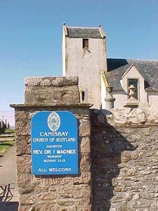
We stopped at the Canisbay Church of Scotland (right) and cemetery. This was the church where the Queen Mother worshiped during her stay at the castle. I videoed a photo of her with the minister. Inside the church I took a shot of the pulpit from the reserved section where the Queen Mother sat for services.
Mey Castle
1556-1572
We timed our visit according to the ferry schedule at nearby John O’Groats where we boarded a ferry for the 45-minute crossing.(map) The day for our Orkney Isles tour was just beautiful and sunny. Bob Kenny told us that this was not typical, especially crossing the straits, because Siberian winds and rain often made warm clothes necessary. The waters were relatively calm and the voyage to Burwick was quite pleasant. The Orkneys, population 17,000, are on the same latitude as Greenland, but have the Gulf Stream to thank for their relatively temperate climate.

On South Ronaldsay (right side of map), with a different tour bus and guide, we soon stopped for sandwiches and pea soup lunch that had been pre-set for our group. After lunch we viewed Scapa Flow, where the German fleet scuttled itself in World War I. In WWII the British navy was based in the Scapa Flow but a German U-boat managed to slip in and sank HMS Royal Oak in 1939. Despite the presence of block ships deliberately sunk during WWI the sub had managed to get through. Therefore, more substantial barriers were ordered by Churchill. We crossed the Churchill Barriers (causeways) built by Italian prisoner of war to protect the British fleet.
Rusted hulls from the earlier block ships still protruded from the water and could be seen from the bus on the causeway.
Then we visited the Italian Chapel built by the Italian prisoners of war in 1943 (photo) from scrap --two Nissen huts, barbed wire, metal, concrete and parts of a rusting block ship.
The beautiful altar painting, Madonna and Child, was painted by prisoner Chiocchetti and was based on a picture he had carried with him. In the group photo of prisoners on the video, he is on the far right. I also taped a photo of him taken in 1960. Chiocchetti led the restoration project in 1960. The chapel is still used for masses.
The Globus bus stopped for a nice visit at Ring of Brodgar, Orkney’s Stonehenge, consisting of 36 standing stones. We had a chance to walk around the ring and take pictures.
The Ring of Brodgar (or Brogar, or Ring o' Brodgar) is a Neolithic henge and stone circle in Orkney, Scotland. Most henges don't contain stone circles; Brodgar is a striking exception, ranking with Avebury (and to a lesser extent Stonehenge) among the greatest of such sites. The ring of stones stands on a small isthmus between the Lochs of Stenness and Harray.
These are the northernmost examples of circle henges in Britain. Unlike similar structures such as Avebury, there are no obvious stones inside the circle, but since the interior of the circle has never been excavated by archaeologists, the possibility remains that wooden items, for example, may be present.
Then on to Skara Brae (above), the remains of a 5,000 year old Neolithic village. Inhabited from about 3,100 BC for 500 years until buried by sand. A storm uncovered the remains in 1850.
On the same premises at Sandwick we visited Skaill House (right). This is one of Orkney’s finest
mansions, with imposing architecture that spans four centuries.
An unexpected treat was an extended visited to Kirkwall, island capital with a distinct Viking flavor and impressive red sandstone. The most compelling of the buildings there was the St. Magnus Cathedral begun in 1137.
The east window dates from the 13th century and the extension of the nave in the 15th century. The bulky interior sandstone columns, the brickwork arches and altar area were all worthy of note, as was the large open Norwegian Bible. Since this was Saturday many locals teemed the downtown area around the church.
The Watergate Tower along with Earls and Bishops Palace remains south of the church. Most of these ruins date from the 16th century.
After leaving Kirkwall we drove past Scapa Flow again; this time more sunken ships were visible than before because of the lowering tide. The ferry ride to John of Groats was pleasant. Back on the mainland of Scotland, I took a parting video shot of the Orkneys with the uninhabited island of Stroma in the foreground.
On the way back to the hotel we saw two palaces/castles of the powerful Sinclair clan that dominated this part of the country (right).
Day 10, Sunday
Our journey today (map) was to be the longest mileage day of the entire tour. We started off early in the morning, crossed the Thurso River and drove through the city of Thurso, visited mostly by people passing through to the nearby port of Scrabster. The town’s name derives from the Norse word Thorsa, literally “River of the God Thor,” and in Viking times this was a major gateway to the mainland. I took a video of buildings in the town (enlarged by the Sinclairs), including St. Peters Church (to right)) with origins to the 13th century. As we left town we could see the Island of Hoy in the distance.
We took the remote northern coast road with its miles of white sandy beaches. Scotland’s rugged northern shore is lined with crumbling cliffs and sheer rocky headlands, backed by barren mountains in the west. We enjoyed wild and unspoiled scenery, some of the finest in Britain. Our drive from Wick to Skye was primarily on a single lane and somewhat uneven roads. Yet, we were pretty comfortable on the coach, except possibly those on the very back seats.
Our bus stopped at Bettyhill (right), a major crofting village along the side of a narrow tidal estuary.
We drove on through remote peat bog country and the inlet at Tongue. In 1746 the Kyle of Tongue was the scene of a naval engagement reputed to have sealed the fate of Bonnie Prince Charlie’s Jacobite rebellion. To the right in the distance was Varick Castle, an 11th century Viking stronghold.
After Durness (Top of map) where we encountered beautiful bays and sandy beaches, we followed the west coast and stopped at the jagged remnants of Ardveck Castle near Lochinver (map). This MacLeod castle stood on a rocky promontory synt presenting a photogenic object for our group. Nearby were interesting ruins of a roofless building I managed to capture from the moving bus.
At Ullapool we stopped for lunch of fish and chips and I took a shot of ships in the lovely harbor. This port is the northwest principal center of population and is still an important fishing town.
A little further on Jimmy parked the bus so we could see falls accessible by a walk from highway A835. Those ambitious enough took the trek to view the spectacular 164 ft Falls of Measach which plunge through the Corrieshalloch Gorge.
We saw the cascades from both an extended wooden viewing platform (two people at a time) and from a swinging suspension bridge that spans the 197 ft chasm. The toughest part of the trek was climbing the steep incline back to our waiting bus.
We made a potty stop at Achansheen (map) along the railway tracks. Nice countryside scenery. Noisy birds prompted me to “shoot” them as they perched on a railroad bridge.
Jimmy pulled the bus over a little later for an extra treat that wasn’t on the itinerary -- the beautiful Eilen Donan Castle on Loch Duich (right). Guide books refer to this castle as Scotland’s most photographed monument. The crenelated tower rises from the water’s edge, joined to the shore by a narrow stone bridge. The original castle was established in 1230 to protect the area from the Vikings. The castle was blown up by the English when the Old Pretender James Stuart occupied it. The castle was rebuilt between 1912 and 1932 and since has been the scene of many major movies, including Highlander.
We crossed to Kyleakin (see map above) on the Isle of Skye via a bridge linking it with Kyle of Lochalsh (map) on the mainland. The Skye Bridge cost 30 million pounds (around $45 million) to build. The toll charged to recoup the cost is so high it is the most expensive toll bridge in Europe.
On the Skye side was soon visible the remains of Castle Moil (right). Skye has a landscape characterized by valleys and high peaks. It is the largest of the Hebridean Islands with a population around 8,000 people who speak mainly Gaelic. It was on this Inner Hebridean Isle of Skye where Bonnie Prince Charlie took refuge after escaping Culloden.
Our evening lodging had been arranged at Dunollie Hotel at Broadford (right) on the Isle of Skye. It was situated off the Inner Sound so that when we stepped out of the dining area we faced a beautiful beach front.
Day 11, Monday
After a scenic drive northward (map) with waterfalls, cloud covered mountains and fields of sheep, we pulled into Portree, the tiny island capital. We were given more than an hour to explore the “village” so I started my walk with the vantage point of “the lump” (background in photo right), a steep and stumpy peninsula that was once the site of public hangings. When I reached the summit there was just me and a bonnie bunny.
The Royal Hotel (right) on Main Street occupies the site of the Mcnab’s Inn where Bonnie Prince Charlie took leave of Flora MacDonald.
Portree is one the most attractive fishing ports in northwest Scotland, circled by multicolored restaurants and guest houses. As I taped a video of the colorful buildings
I couldn’t help but notice all of the seagull activity on the docking area. This prompted me to walk down to the waterfront, a dangerous undertaking with all the birds lying overhead. I escaped unscathed and was rewarded with a nice view of active birds and the harbor with surrounding mountains.
From Portree we headed for Dunvegan and saw the Fairy Bridge en route where legend has it that a MacLeod chief foolishly married to a fairy and was forced to say farewell when she decided to go home to her mother.
We then visited remote Dunvegan Castle, seat of the chiefs of Clan MacLeod since 1200, but the present rectangular fortress with its uniform battlements dates from the 1840s.
Before entering I shot a view of Dunvegan Loch from the moat area.
Inside I caught the interior of the Fairy Tower and the drawing room which is host to the Fairy Flag. When I entered the drawing room beautiful violin music was being played, but before I could tape the musician playing she had stopped playing and was putting away her instrument.
Stepping out into the outer court on the sea side I had a different perspective of the castle. The water garden here was fed by a flowing stream of water that cascaded like waterfalls. We ate lunch at a restaurant where the bus was parked, a restaurant called MacLeod. Jimmy chose a different route for our return trip to Broadford -- a narrow single lane road that I’m sure was not a regular highway. This seashore drive was so delightful that I taped considerably through the bus windows.

For those who signed up for the optional trip to visit the locals we left the hotel for different scenery on the route to Elgo (map) at the tip of the Strahaird peninsula. The Red Cullins were on our right and the Black Cullins to the left. We passed foundation ruins and walls of old buildings and, at Kilchrist, the ruins of a pre-Reformation church and cemetery. Then we had Mt Blaven before us on the left, the highest peak in the Black Cullins. According to Bob Kenny, this was MacGinnis country. At Elgo we parked by the Cullin View Gallery and Coffee Shop where a lookout point afforded excellent views of the offshore islands of Soay or Eigg, Rum and Canna in Loch Scavaig.
See map.
The evening’s activity was to drink beer or ale while being informed of crofter life from two kilt-wearing Scots. We had our choice of many brews, three of which were brewed right on the Isle of Skye. I choose the dark Black Cullin Ale and the Gold Hebrides Ale (light oat porridge), both of which were very satisfying.
Day 12, Tuesday
Another hefty Scottish breakfast and we were off to learn about the MacDonalds. We left Broadford for the relatively short trip to Armadale on the Sleat (pronounced Slate) peninsula. I wasn’t overly impressed with the exhibits at the Clan MacDonald Center, but the 40 acre flower gardens and castle made up for any disappointment. The flowers and arrangements were fantastic. The neo-Gothic Armadale Castle was built by the MacDonalds, Lord of the Isles, as their clan seat in 1815.
We boarded CalMac ferry at Armadale to sail across the Sound of Sleat to the mainland at Mallaig. We drove along the sandy beach area where Bonnie Prince Charlie landed. Our bus followed the “Road of the Isles” pausing at Glenfinnan at Loch Shiel where Bonnie Prince Charlie raised his standard in 1745 to start the Jacobite uprising. A 66 foot column crowned with a clansman in full battle dress has been erected here to mark the occasion. From here Charlie set off for his long march to London.
Also of interest in the area was the mighty 21 arched viaduct built in 1901 and one of the first ever large constructions made out of concrete.
The third great object of interest here was Fred making friends with a falcon while an owl observed the tantalizing event.
The drive along Loch Linnhe on a single lane road tested the driving skill of Jimmy. Periodically there were passing spaces so cars could pull over and let oncoming traffic through. We had incidences where our bus or other cars had to stop and backup into those spaces. Still, Jimmy made pretty good time. So much so that the lady behind me spoke quite loudly, “The road sign says S-L-O-W.” Bob didn’t appreciate the spelled out hint meant for Jimmy and said, “If we don’t reach the ferry in time we S-W-I-M.” The lady responded, “I guess you shut me up.” Bob retorted, “I hope so.”

To our left was the mighty Ben Nevis. When we left Loch Linnhe we turned right and headed to Loch Sunart and then though MacGinnis country to Lochaline. At Lochaline we could see the Maginnis Castle and Mansion (right). The camcorder had to be zoomed in for more detail. We also could sit back and admire the Isle of Mull across the sound. Our bus entered the jaws of the car ferry and we pulled off the boat in Fishnish.
We signed in at our lodging at Isle of Mull Hotel at Craignure. See map above. I had a little time before our optional excursion, so I walked around to the back of the hotel to observe the Sound of Mull. This afforded a nice view of hotel from the back. The garden at the hotel had many so beautiful roses that had to tape record them.
Our optional tour to Torosay Castle began with a train ride along the sound on the Mull and West Highland Railway miniature train. This took us right up to the castle, stopping only to pull over on a side track for an on-coming train.
The castle was a full blown Scottish Baronial creation. The Laird himself conducted us through his ancient home, pointing out a portrait of his great-grandmother. His mother, who was in the gift shop, had a sister who married into the Churchill/Wm A. Harriman families. As we were touring rooms, I noticed that you could see Duart Castle of the McLeans from the windows.
Just below us could be seen the magnificent gardens and fountains. After the house tour I spent considerable time among the statues and formal gardens. The Laird possessed much property -- over 8,000 acres. Back at the hotel that night we were treated to entertainment in the lobby that featured accordion players and a little puppetry.
Day 13, Wednesday
The agenda for today is to drive across Mull (previous map) and explore the Isle of Iona the center of Celtic Christianity. Stretching for twenty miles west as far as Iona is Mull’s rocky southernmost peninsula, the Ross of Mull. We passed by Ben More, literally “big mountain.” To the right in the distance are the Treshnish Isles. Mendelssohn’s Die Fingalshokle was inspired by the sounds of sea-wracked caves which he heard on a visit there in 1829. Allegedly, St. Columba banished snakes (and some say, frogs) from Iona. Bob Kenny said he did not rid Mull of snakes because one poisonous variety still strives here. A sign along the highway reminded us that this is Argyll country.

We arrived at the Isle of Iona at the island’s main village, Baile Mor, which is little more than a single terrace of cottages facing the sea. (map) In 1203, Iona became part of the mainstream church with the establishment of an Augustinian Nunnery. During the Reformation the complex was destroyed. Today we see the pink granite ruins.
Just down a path stands the fifteenth century MacLean’s Cross, a fine late-medieval example of the distinctive, flowing, three-leaved foliage of the Iona school.
St. Oran’s Chapel lies south of the Abbey and boasts a door dating to the eleventh century. On the grounds are burial places of sixty kings of Norway, Ireland, France and many of Scotland, including Duncan and Macbeth. Later I taped grave sites bearing the name of MacGinnis.
To the right is the Abbey. No buildings remain from Columba’s time. The present abbey dates from the arrival of the Benedictines around 1200. They were responsible for the conversion of more or less all of pagan Scotland as well as much of northern England. The monks compiled a vast library of intricately illuminated manuscripts -- most famously, the Book of Kells, which we saw at Trinity College when we were in Dublin, Ireland.
The monastery here was extensively rebuilt in the fifteenth and sixteenth centuries, and restored virtually wholesale this century when the owner, the eighth duke of Argyll donated the buildings to the Church of Scotland. I walked around the cloisters and the main chapel. The white marble effigies of Argyll and his wife lie in a side chapel.
After touring the historic sites we retired to the Martyrs Restaurant for lunch, so named because of a Viking raid and the massacre of 68 monks on the sands of Martyrs’ Bay in the year 806. Today children gleefully play on the beach. The village of Baile Mor is in the background.
We returned to Mull (map) and headed across the island and then up to Tobermory. Some black cows had wandered onto the single lane highway and blocked traffic. The poor perplexed animals did not know what to do and futilely just ran along the road only to encounter traffic from the other direction. Finally the dilemma was resolved when they came to a side driveway. The whole busload of passengers snapped pictures of the pathetic creatures.
Finally we arrive at Tobermory, the quaint island capital. The most dramatic event in Tobermory history was in 1588 when a ship from the Spanish Armada sank in mysterious circumstances while having repairs done to its sails and rigging. The story goes that one of the MacLeans of Duart Castle was taken prisoner, but when the ship weighed anchor, he made his way to the powder magazine and blew it up. As late as 1982 attempts have been made to locate the sunken ruins.
I taped a picture of a child fishing for his own treasure on the tidal bank along the bay. Our return trip to Craignure brought us in contact with more beautiful scenery along the Sound of Mull, as well as the sight of Aros Castle (near Salen) of the Clan McDougall.
Day 14, Thursday
We had only a short ride (just a tick) to board the ferry from Craignure to Oban (map). As we waited on the pier for the boat we amused ourselves by watching swimming jellyfish from the dock.
Once underway the ferry took us within short distance of Duart Castle, seat of the MacLean Clan. The MacLeans had ruthlessly suppressed the MacKinnon Clan to firmly establish themselves. The Duart Castle became the headquarters of the MacLean Clan from the 13th century until the 1745 rebellion.
Because the MacLean Clan supported the Bonnie Prince Charlie faction, their castle was seized and burned by the Campbells. The clan chief was left with no power, no pride, no purpose. The wearing of tartans and kilts, and the owning of weapons of any kind were forbidden on pain of death or long term imprisonment.
Even the speaking of Gaelic was prohibited (pp. 196-198, History of Scotland, by Peter and Fiona Somerset Fry, Barnes and Noble, 1995). The fundamental character of these Scotsmen allowed them to persevere, though some fled to the Colonies. In 1911, the 26th clan chief, Fitzroy MacLean (1835-1936) managed to buy Duart Castle back and restore it. One can peek at the dungeons, which once held prisoners from a Spanish Armada (1588) galleon that was sunk by Donald MacLean. Also it is possible to visit the Banquet Hall, climb up the ramparts, study the family photos, and learn about the world scout movement -- the 27th clan chief became Chief Scout in 1959. After a visit one can enjoy home-made cakes and tea in the tearoom. (pp. 321-323, Scotland, by Humphreys, Reid and Tarrant, London, 2000; and p. 133 Eyewitness Travel Guide of Scotland, 1999).
The MacLeans were a proud people. The meanest and lowest member of the MacLeans was devoted to his name. He might even die for it, calling it out as his last words. One catch phrase repeated time and again by MacLeans is “Though poor, I am noble. Thank God I am a MacLean.” (pp. 33-34, History of Scotland, by Peter and Fiona Somerset Fry, Barnes and Noble, 1995). Note: Duart Castle was recently used in the movie Entrapment, starring Sean Connery.
Our island ferry passed the lighthouse on Lismore and the rocky ruins of Dunollie Castle, a McDougall stronghold on a very ancient site (abandoned after 1745), before reaching Oban, Argyll’s chief ferry port of seven thou-sand inhabitants. Standing out among the buildings was the Cathedral of St. Columba built in the 1920s by Sir Giles Gilbert Scott. McCraig’s Folly, a remarkable sight and the city’s landmark, was built in imitation of Rome’s Colosseum by a local citizen who died before completion. Only the exterior granite walls are standing.

After our bus was taken off the ferry, we proceeded out of town. Just north of town we could see, only fleetingly, Dunstaffnage Castle, originally a MacDougall fort. Jimmy stopped at Loch Etive along the highway permitting us to take pictures of long haired cattle. We drove through the Pass of Brander. Because we were forewarned, I taped it through the front windshield. Jimmy made another stop for pictures of 15th century Kilchurn Castle on Loch Awe -- one of Argyll’s most photogenic loch-side ruins (right). On the subject of Loch Awe, Bob Kenny told a God awe full joke (or was it an awe God joke?). Jimmy made another stop for us to take pictures of sheep.

At last we reached Inveraray (right) built on the site of a ruined fishing village in 1745 by the third Duke of Argyll, head of the powerful Campbell clan. As we got off the bus, we were treated to the music of bagpipes by a Highlander. With time to stroll around the city, I started with the distinctive Main Street with its Scottish Georgian architecture. Down the street, in a prominent central location, was the town’s neoclassical church. East of the church was the Inveraray Jail. From Front Street one had a captivating view of the still waters of Loch Fyne and an attractive bridge in the background.
When we left Inveraray, we crossed that bridge very slowly to enable us to get a good look at Inveraray Castle. Inside the Inveraray Castle are displays of weaponry -- supplied to the Campbells by the British government to put down the Jacobites in the massacre of the MacDonalds at Glen Coe.
From Inveraray we followed the road “Rest and be thankful” to the “Bonnie Banks” of Loch Lomond. Perhaps the most popular and best loved loch, Loch Lomond is the largest body of water in the British Isles (22 miles long and 5 miles wide). We stopped at a parking area and walked over to the beach teeming with people “on holiday.”
Finally we were back in Glasgow. A disastrous fire in 1677 had laid waste much of the city and it was afterwards rebuilt wonderfully in Scottish stone by Scottish craftsmen and artisans, with wide streets and Georgian style architecture. Bob gave us a brief city tour which included an exterior look at the University of Glasgow University on right (designed by Sir Gilbert Scott, with a turreted tower) and the Hunterian Art Gallery.
While Bob led the group to St. Giles Cathedral in Old Town, I taped a statue of William III in a nearby park. I had started the tour two weeks ago with a parade to William III and now it seems as if I had gone full circle and ended with the same old gentleman.
Globus held their farewell party at our hotel dinning room in the Glasgow Novotel. Some members of our group made up poetry as tributes to Bob and Jimmy and we toasted them for a job well down.
The thistle flowers that graced our table reminded us of the great land of Scotland. The good food was representative of the many fine meals we were served on the trip. Table mates were kind and gracious people who contributed tremendously to a successful tour. All things had gone well and we closed on a happy note.
Day 15, Friday
Another full Scottish breakfast started our day. Bob accompanied us on the bus to the airport and showed us the airport departure entrance, only a tick away. Air Canada provided our international flight to Toronto, Canada. From Toronto we split up and went our different ways.


No comments:
Post a Comment