
8 Days - $995 (CARAVAN) Fred recorded with camcorder; Annette took photos. Narrative follows the ordedr in camcorder video. The Caravan Latin America tour included all meals, all activities, all hotels, a great itinerary, all airport transfers, and all transportation and excursions. A professional tour director, named Tony Valdez accompanied us for the entire tour. We had purified water at meals and free bottled water on the motor coach. Caravan has been in business for more than 50 years and it showed. A
Pre-trip Jan. 13, Saturday, Minneapolis
We left New Ulm in the evening. In Maple Grove we visited Kim and Tom for pizza and TV playoff football. Then we headed to Bloomington La Quinta (former Clarion) Motel. Parking fee (up to 14 days) was included in $119 price. Minneapolis Star newspaper was complimentary and we were provided with a nice breakfast.
Day 1, Jan. 14, Sunday – El Paso, Texas

We took Delta (Skymiles awards) to Atlanta and then to El Paso. Our group stayed at the Hilton El Paso Airport (now called the WYNDHAM).
Geberts and Jean had checked in earlier. We called them from our room. Don and Jean came over for a brief get-together and a photo shoot.
Temps were supposed to be in upper 50s. Rest of the trip was to have highs in the 60s. Since this was a predominantly casual tour, casual wear was suggested for sightseeing and daytime traveling. Dress code for most evenings was smart casual. Evenings would always be cool (30s) so we brought jackets and sweaters. It turned out that weather was cooler than expected. We also had much more rain than usual. Northern Mexico had just experience a seven year drought and now seemed to be catching up for the missed precipitation.
Day 2, Jan. 15 –Monday - El Paso to Creel, Mexico

Bags were put out by 6:00 a.m. Before departing at 7:00 a.m., I taped Don boarding the bus and ambling down the aisle to his seat.

The mountain that can be seen out the window in the background is the obstacle that necessitated the
pass (El Paso) around it.We crossed the Rio Grande into Mexico at Juarez. Our bus stopped while Tony
talked to border officials. As we waited for the formalities to be completed, we noticed a banner depicting Benito Juarez, from whom the city was named. All over Mexico
pass (El Paso) around it.We crossed the Rio Grande into Mexico at Juarez. Our bus stopped while Tony
talked to border officials. As we waited for the formalities to be completed, we noticed a banner depicting Benito Juarez, from whom the city was named. All over Mexico
he is featured in monuments

And currency.
Benito Pablo Juárez García (March 21, 1806 – July 18, 1872) was a Zapotec Amerindian who served five terms [1] (1858–1861), (1861–1865), (1865–1867), (1867–1871), and (1871–1872), as President of Mexico. For resisting the French occupation, overthrowing the Empire, and restoring the Republic, as well as his efforts to modernize the country, Juárez is often regarded as Mexico's greatest and most beloved leader. He is the only full-blooded indigenous national to serve as President of Mexico.
Benito Pablo Juárez García (March 21, 1806 – July 18, 1872) was a Zapotec Amerindian who served five terms [1] (1858–1861), (1861–1865), (1865–1867), (1867–1871), and (1871–1872), as President of Mexico. For resisting the French occupation, overthrowing the Empire, and restoring the Republic, as well as his efforts to modernize the country, Juárez is often regarded as Mexico's greatest and most beloved leader. He is the only full-blooded indigenous national to serve as President of Mexico.

As we exited the border control, we passed in full view of the mountains cited earlier as north of El Paso. The rustic and reddish Franklin Peak towers at 7,192 feet above sea level and is the highest peak in the city, which can be seen from the distance of roughly 60 miles from all directions.

After driving a distance of about 50 kilometers from Ciudad Juarez we came across the expansive pristine Samalayuca Sand Dunes.
We reached it by taking the Pan American Highway that crosses the endless Chihuahua plains. We had witnessed the plains covered with short bushes or yellowish grasslands. The flat terrain’s horizontal lines gave way to gentle curves, and the scarce vegetation ended up disappearing.
Just like dunes on a beach, these sand dunes are sandy mounds of all sizes, which have been built after thousands of years of erosion. Although many parts of Mexico have deserts, very few of them are so arid that they actually have hills of fine sand like this one.
There is the legendary challenge of people living in a desert: being lost in a labyrinth with no walls. The sand dunes of Samalayuca, like the rest of northern Chihuahua and Sonora, belong to a geographic region that extends into several western regions of the United States (mainly Nevada, Utah, Arizona, and New Mexico), which is known as “basin and range”. It is formed by dozens of basins separated by small mountain ranges, which generally follow a north-south direction. This fact is comforting to know for hikers walking on the sand dunes: at any moment you can find your bearings by looking at the small sierras, which despite not being too long they stand about 500 meters above the prairie.
The irony is that the plains were made by the water we could not see anywhere. Many years ago, lakes made up a large part of the “basin and range” region and deposited sediments between the mountains. Marine fossils found under the sand prove that a large body of water once lied on the sand dunes.
The incredible thing about these large mounds is that they are made up of tiny grains of sand about a millimeter in diameter: the work of the wind, which has brought all this sand to northern Chihuahua. But, where did it bring it from? It could be that the sand was brought over thousands of years by the powerful “nortes” (storms) that pick up sand from what is now the United States. This, however, is just a hypothesis: there are no specific climatic studies that give an answer to the origins of all this sand.
What is an obvious fact is that the sand dunes move. The Central Railroad, built in 1882, attests to this movement. In order to keep the sand from “swallowing” the tracks, two protecting lines made of thick tree trunks were stuck on the ground. These were best seen on our trip back to El Paso on the return trip. The tracks run parallel to the highway. Shortly a train cam down the tracks for the camera. Some high dunes are only a few steps from the side of the road. To see the really high ones require driving off the highway. Tony said that what appear as mountains around us are not shown on maps as mountains, but rather they are called sky islands.
Weldon Heald coined the term "sky islands" in 1967 to denote mountain ranges that are isolated from each other by intervening valleys of grassland or desert. The valleys of this basin and range country act as barriers to the movement of woodland and forest species somewhat like saltwater seas isolate plants and animals on oceanic islands. The 40 ranges of the Sky Island system may be thought of as an archipelago.

We continued through huge expanses of rangeland and occasional pecan tree orchards. Finally we approached the City of Chihuahua. Tony pointed out housing on the outskirts of the city that were built in stages over years by young couples. He also showed us more recent structures that were part of government-planned communities, whereby loans were secured for immediate occupation of finished structures.
These buildings were relatively new and attractively painted, but were really quite small compared to our standards.
These buildings were relatively new and attractively painted, but were really quite small compared to our standards.

The large prominent mountain within the city was a landmark called “The Big Mountain.”
We stopped for lunch at a Mexican restaurant in Chihuahua called La Quinta (“The Country”). Our first meal in this country was a plate (set menu) of various Mexican specialties, which went over well.

We changed highways and were now on a journey through Mennonite country towards Creel. The hard-working Mennonites have transformed the desert into fertile farmland.
We passed through vast apple orchards rigged with weather protection devices that could provide cover during inclement weather. The driver evidently ran over some wood that lodged in a wheel well which prompted him to stop the bus. We had just crossed over a bridge and had a nice view of a riverbed below. I zoomed in on two Indian women who were washing their clothes in the river.


Tony joined in and contributed as if he was an integral part of the group. Obviously Annette, who had a ringside seat, fully enjoyed herself. Our dinner in Creel was served in the large seating area of the restaurant. Naturally, the fare was authentic Mexican food.

The hotel featured a restaurant, bar, and lobby with fireplace.

Our room had two double beds, high wood-beamed ceiling, central heating, and tiled bathroom. However, we were instructed to put happy paper in the wastebasket instead of in the toilet to ease the plumbing situation.

Day 3, Jan 16 – Tuesday - Copper Canyon Train, Divisadero
Before breakfast I taped the rustic wooden walkway (porch) that ran along our doorways. At the end of the building our bus was tucked away for the night. Our five-some met in the restaurant where a non-English speaking lady took our orders. My “American” breakfast consisted of two fried eggs, bacon and refried beans (covered with shaved cheese). The toast was exceptionally good (must have been made with homemade bread). On the wall was a painting of a Tarahumara Indian woman that was worth a picture.

As I waked back to my room I came across a Tarahumara Indian woman very colorfully dressed who was accompanied by a little girl. After seeking permission, I videotaped them and gave the child a couple of dollars. With free time in the morning some toured the Mission Store, a trading post that buys crafts from Tarahumara Indians and resells to visitors. All profits benefit the Tarahumara Indian hospital.
The Tarahumara are a Mexican Indigenous people of northern Mexico, renowned for their long-distance running ability. The long-distance running tradition also has ceremonial and competitive aspects. Often, the runners kick wooden balls as they run. The Tarahumara women wear the traditional brightly colored clothes they are famous for. They make and sell hand made items.
Originally inhabitants of much of the state of Chihuahua, the Tarahumara retreated to the Copper Canyon in the Sierra Madre Occidental on the arrival of Spanish explorers in the sixteenth century. Current estimates put the population of the Tarahumara in 2003 at between 50,000 and 70,000 people. Most still practice a traditional lifestyle, inhabiting natural shelters such as caves or cliff overhangs, as well as small cabins of wood or stone. Staple crops are corn and beans; however, many of the Tarahumara still practice transhumance, raising cattle, sheep, and goats. Almost all Tarahumara migrate in some form or another in the course of the year.
The Tarahumara religion is a mélange of indigenous customs and Roman-Catholic Christianity, characterized by a belief that the afterlife is a mirror image of the mortal world, and that good deeds should be performed not for spiritual reward, but for the improvement of life on earth. The Devil and God are brothers (the Devil is the elder) who jointly created the human race. The Tarahumara share with other Uto-Aztecan tribes veneration for Peyote, the spirits of which are said to be mischievous and capricious.


With Caravan we traveled both the south and the north route in a spacious air-conditioned chartered first class train car. Our first class Copper Canyon cars have been newly refurbished. Ferrocaril Mexicano operates them, exclusive owners of the Copper Canyon rail route.
Both our Copper Canyon train rides were scheduled in the daytime for the best lighting for views and photography. With Caravan’s roundtrip train ride we saw a different side of the Copper Canyon in each direction.
Caravan had reserved an entire first class train car. For our comfort, there were always more seats in our car than there were clients. For our personal safety, the seats in our train car were only available to Caravan clients and were not open to the general public. Shortly after boarding in Creel, the train circled back over itself in a complete loop known as El Lazo.
Once aboard the train, Tony gave us instructions as if he were an airline stewardess. He gave direction to the exits and the restrooms located on each side in front of our car and at both sides of the rear. I turned the camera from Tony to Jean and Annette who obviously enjoyed Tony’s sense of humor.

When lunchtime came, we headed toward the dinning car, traversing a number of cars and links between cars. The dinning car could seat only 42 passengers, so Jean, Annette and I had to eat by ourselves in the club car. We ate in style and even had coffee, a drink not available in the commoner’s dinning car.

The train was now traveling on a plateau and trees lined both sides of tracks. When the train rounded a bend I could take a shot of the engine and cars in front of us.

With an oncoming train approaching our engineer pulled our train over onto a siding. When local Indians saw us stop they approached the train with their wares.


Dinner is in the dining car. We arrived in the picturesque colonial town of El Fuerte (map) a relaxing two nights at a restored colonial mansion (map), the Posado del Hidalgo. Our bus dropped us off at the “top” of the hotel (or back door) that was close to our rooms and saved us a long uphill walk if we had been dropped off at the (bottom) entrance.

Day 4, January 17th – Wednesday - El Fuerte

Fred got up early this morning to explore the grounds. This beautiful hotel is a former colonial mansion built by Señor Rafael Almada in 1890 for 100,000 gold pesos. Most of the original pine beams and furniture were brought by boat from San Francisco, California. The hotel featured a swimming pool, restaurant, high ceilings with wood beams and two story balconies. Most of the rooms are air-conditioned and all have private tile baths.


Hummingbirds were buzzing about the breakfast area. Our gang of five ate breakfast together in the Pinata Room with “the silent one” (who eventually moved).
The rainy weather discouraged many (about half) of our groupo from taking an El Fuerte River float trip this morning. Those who did participate saw parrots, woodpeckers, kiskadees, kingfishers, doves, cormorants and other desert birds in their natural habitat. Literature we received mentioned the Mayo Indians living in the area.
The Posada del Hidalgo was centrally located for exploring El Fuerte. Tony led an expedition around the town, but Annette opted out because of the required walking We started out at the beautiful courtyard and a fountain within the hotel and then down stairs and a ramp to a large covered cave-like side exit that had painted murals on one wall. One painting depicted an early Catholic missionary to the area.


After a Tony Talk we walked on the cobblestone street to the charming plaza of El Fuerte or Main Square. Standing in the rain we soaked in the large central gazebo, a statue of Juarez and water fountains. Next to the Square was the 17th century cathedral.


On the outside patio of this restaurant was a statue of a little boy peeing -- just like the famous statue in Brussels, Belgium. Fred had ordered shrimp shish-ka-bob for Annette and it proved to be a good choice for her. After lunch, the afternoon was at leisure to stroll the, center of all social life.

Zorro (sometimes with the definite article: El Zorro), Spanish for Fox, is the secret identity of Don Diego de la Vega (originally Don Diego Vega), a fictional nobleman and master swordsman living in Spanish-era California. He defends the people, Robin Hood-style, from the corrupt tyranny of the Spanish governor, proving himself much too cunning and foxlike for the bumbling authorities to catch. He was created by pulp writer Johnston McCulley, and first made his appearance in The Curse of Capistrano, serialized in the pulp magazine All-Story Weekly in 1919.
The character's visual motif is, typically, a black costume with a flowing Spanish cape, a flat-brimmed Andalusian-style hat, more appropriate to a California caballero than the wide sombrero the character wore in the original, and a black cowl mask that covers the top of the head from eye level upwards. (The mask covered his whole face in the original.) In addition, his favored weapon is a rapier that he often uses to leave his distinctive emblem, a large 'Z' made with three quick cuts. He also uses a bullwhip, like the later Indiana Jones. In the original story, Zorro also used a pistol. It has been noted that Zorro was actually one of the original inspirations for the creation of The Phantom and Batman, as well as many other comic-strip action heroes. Later on our trip, Tony played a Zorro DVD on the bus for us.


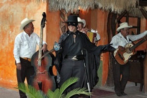
Cribbage occupied the gang until we moved over to the poolside for the pre-dinner entertainment.


Day 5, 18th –Thursday - Copper Canyon Train

We put our bags out at 6 am, had a nice breakfast and departed for our chartered train car for another thrilling train ride through the Canyon. The train was not at the terminal yet. As we waited I videoed a cat perched on the roof of a humble house near the tracks. When the train approached us I caught the action, along with Don who was snapping a picture of the locomotive.


The entire railroad passes through 86 tunnels and 38 bridges in the 25,000 square mile canyons of the Sierra Madre. The five major canyons are collectively known as the Copper Canyon, which is four times the size of the U.S. Grand Canyon. The Tarahumara Indians live in the Canyon. We stopped this morning in Temoris where we could see three ascending levels of the railroad. Annette, Jean and I enjoyed lunch on board in the club car again.. Our round trip train ride gave us a second chance to view the grandeur of the Canyon.
GO TO 2007 COPPER CANYON II
No comments:
Post a Comment